Thetford geodata
Thetford (England) is a populated place; located in United Kingdom in Europe/London (GMT+1) time zone. With population of 24,833 people, there are 483 cities with bigger population in this country. Compared to other cities in United Kingdom, 51.4% of cities are located further ↑North; 94.6% of cities are located further ←West and 77.1% of cities have higher elevation than Thetford. Note1
Administrative division(s):
- Level 1: England
- Level 2: Norfolk
- Level 3: Breckland District
- Level 4: Thetford


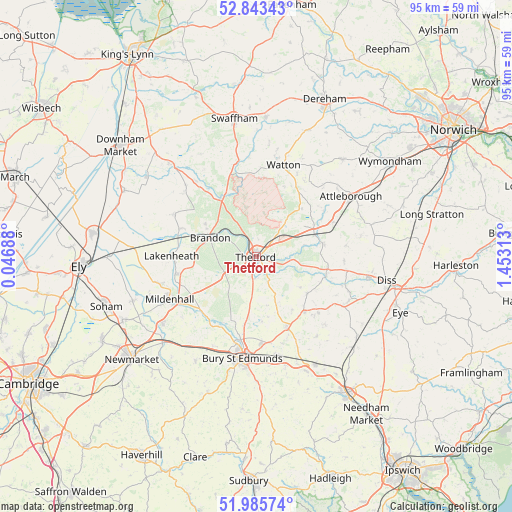
Thetford GPS coordinates[2]
52° 25' 0.012" North, 0° 45' 0" East
| Map corner | latitude | longitude |
|---|---|---|
| Upper-left | 52.84343°, | 0.04688° |
| Center: | 52.41667°, | 0.75° |
| Lower-right: | 51.98574°, | 1.45313° |
| Map W x H: | 95.4×95.4 km | = 59.3×59.3mi |
| max Lat: | 60.39635° ⇑51.4% North |
| Thetford: | 52.41667° |
| min Lat: | ⇓48.6% South 34.60088° |
| min Long | Thetford | max Long |
| -7.64133° | 0.75° | 32.95536° |
| W 94.6%⇐ | ⇒5.4% E |
Elevation
Elevation of Thetford is 24 m = 79 ft, and this is 48.9 m = 160 ft below average elevation for this country.
| Max E: |
515 m = 1690 ft | 77.1% |
| Avg. | 72.9 m = 239 ft | |
| Thetford | 24 m = 79 ft | |
Min E: |
-30 m = -98 ft | 22.9% |
See also: United Kingdom elevation on elevation.city.
Geographical zone
Thetford is located in North temperate zone (between Tropic of Cancer and the Arctic Circle). Distance of this North polar circle is 1573 km =977.4 mi to North.| Distance of | km | miles | from Thetford |
|---|---|---|---|
| North Pole | 4178.9 | 2596.6 | to North |
| Arctic Circle | 1573 | 977.4 | to North |
| Tropic Cancer | 3222.3 | 2002.2 | to South |
| Equator | 5828.2 | 3621.5 | to South |


Nearby cities:
15 places around Thetford: (largest is in red/bold)
• Bardwell
12.1 km =7.5 mi,  146°
146°
• Barningham
11.6 km =7.2 mi,  127°
127°
• East Harling
12.7 km =7.9 mi,  78°
78°
• Garboldisham
13.6 km =8.5 mi,  100°
100°
• Great Barton
16.1 km =10 mi,  175°
175°
• Hepworth
14.5 km =9 mi, 130°
• Hockwold cum Wilton
14.8 km =9.2 mi,  290°
290°
• Hopton
12.9 km =8 mi,  112°
112°
• Ixworth
14.3 km =8.9 mi,  156°
156°
• Lakenheath
15.5 km =9.6 mi,  270°
270°
• Mundford
12.3 km =7.6 mi,  326°
326°
• North Lopham
16.5 km =10.3 mi, 95°
• Shropham
15 km =9.3 mi,  51°
51°
• Snetterton
13.8 km =8.6 mi,  61°
61°
• Weeting
10.6 km =6.6 mi,  300°
300°
Sources, notices
• [Note1] Compared only with cities in United Kingdom existing in our database
• [Src1] Map data: © OpenStreetMap contributors (CC-BY-SA)
• [Src2] Other city data from geonames.org with taken over terms of usage.
• [Src3] Geographical zone / Annual Mean Temperature by Robert A. Rohde @ Wikipedia
