Tenbury Wells geodata
Tenbury Wells (England) is a populated place; located in United Kingdom in Europe/London (GMT+1) time zone. With population of 3,849 people, there are 1885 cities with bigger population in this country. Compared to other cities in United Kingdom, 53.7% of cities are located further ↑North; 66.9% of cities are located further →East and 53% of cities have higher elevation than Tenbury Wells. Note1
Administrative division(s):
- Level 1: England
- Level 2: Worcestershire
- Level 3: Malvern Hills District
- Level 4: Tenbury


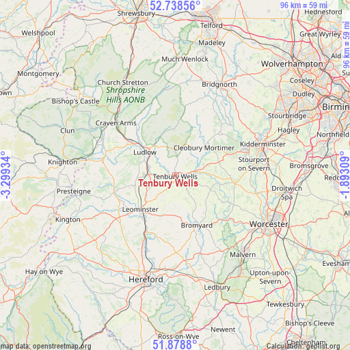
Tenbury Wells GPS coordinates[2]
52° 18' 38.772" North, 2° 35' 46.356" West
| Map corner | latitude | longitude |
|---|---|---|
| Upper-left | 52.73856°, | -3.29934° |
| Center: | 52.31077°, | -2.59621° |
| Lower-right: | 51.8788°, | -1.89309° |
| Map W x H: | 95.6×95.6 km | = 59.4×59.4mi |
| max Lat: | 60.39635° ⇑53.7% North |
| Tenbury Wells: | 52.31077° |
| min Lat: | ⇓46.3% South 34.60088° |
| min Long | Tenbury Wells | max Long |
| -7.64133° | -2.59621° | 32.95536° |
| W 33.1%⇐ | ⇒66.9% E |
Elevation
Elevation of Tenbury Wells is 56 m = 184 ft, and this is 16.9 m = 55 ft below average elevation for this country.
| Max E: |
515 m = 1690 ft | 53% |
| Avg. | 72.9 m = 239 ft | |
| Tenbury Wells | 56 m = 184 ft | |
Min E: |
-30 m = -98 ft | 47% |
See also: United Kingdom elevation on elevation.city.
Geographical zone
Tenbury Wells is located in North temperate zone (between Tropic of Cancer and the Arctic Circle). Distance of this North polar circle is 1584.8 km =984.7 mi to North.| Distance of | km | miles | from Tenbury Wells |
|---|---|---|---|
| North Pole | 4190.6 | 2603.9 | to North |
| Arctic Circle | 1584.8 | 984.7 | to North |
| Tropic Cancer | 3210.5 | 1994.9 | to South |
| Equator | 5816.4 | 3614.1 | to South |


Nearby cities:
15 places around Tenbury Wells: (largest is in red/bold)
• Brimfield
6.8 km =4.2 mi,  266°
266°
• Bromfield
14.1 km =8.8 mi,  304°
304°
• Cleobury Mortimer
10.8 km =6.7 mi,  45°
45°
• Clifton upon Teme
13.6 km =8.5 mi,  118°
118°
• Collington
8.7 km =5.4 mi,  141°
141°
• Elton
14.1 km =8.8 mi,  280°
280°
• Eyton
12.5 km =7.8 mi,  237°
237°
• Humber
13.2 km =8.2 mi,  201°
201°
• Kimbolton
9.8 km =6.1 mi,  226°
226°
• Leominster
13.8 km =8.6 mi, 226°
• Ludlow
10.6 km =6.6 mi,  311°
311°
• Luston
11.9 km =7.4 mi, 244°
• Orleton
10.5 km =6.5 mi,  263°
263°
• Thornbury
9.2 km =5.7 mi,  159°
159°
• Wacton
10.7 km =6.6 mi,  169°
169°
Sources, notices
• [Note1] Compared only with cities in United Kingdom existing in our database
• [Src1] Map data: © OpenStreetMap contributors (CC-BY-SA)
• [Src2] Other city data from geonames.org with taken over terms of usage.
• [Src3] Geographical zone / Annual Mean Temperature by Robert A. Rohde @ Wikipedia
