Tamworth geodata
Tamworth (England) is a populated place; located in United Kingdom in Europe/London (GMT+1) time zone. With population of 81,964 people, there are 125 cities with bigger population in this country. Compared to other cities in United Kingdom, 53.4% of cities are located further ↓South; 51% of cities are located further ←West and 57.7% of cities have lower elevation than Tamworth. Note1


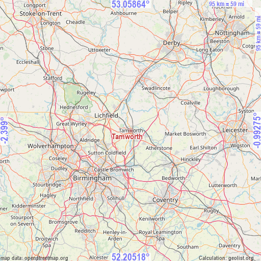
Tamworth GPS coordinates[2]
52° 38' 2.364" North, 1° 41' 45.132" West
| Map corner | latitude | longitude |
|---|---|---|
| Upper-left | 53.05864°, | -2.399° |
| Center: | 52.63399°, | -1.69587° |
| Lower-right: | 52.20518°, | -0.99275° |
| Map W x H: | 94.9×94.9 km | = 59×59mi |
| max Lat: | 60.39635° ⇑46.6% North |
| Tamworth: | 52.63399° |
| min Lat: | ⇓53.4% South 34.60088° |
| min Long | Tamworth | max Long |
| -7.64133° | -1.69587° | 32.95536° |
| W 51%⇐ | ⇒49% E |
Elevation
Elevation of Tamworth is 73 m = 240 ft, and this is 0.099999999999994 m = 0 ft above average elevation for this country.
| Max E: |
515 m = 1690 ft | 42.3% |
| Tamworth | 73 m 240 ft | |
| Avg. | 72.9 m = 239 ft | |
Min E: |
-30 m = -98 ft | 57.7% |
See also: Tamworth elevation on elevation.city.
Geographical zone
Tamworth is located in North temperate zone (between Tropic of Cancer and the Arctic Circle). Distance of this North polar circle is 1548.8 km =962.4 mi to North.| Distance of | km | miles | from Tamworth |
|---|---|---|---|
| North Pole | 4154.7 | 2581.6 | to North |
| Arctic Circle | 1548.8 | 962.4 | to North |
| Tropic Cancer | 3246.4 | 2017.2 | to South |
| Equator | 5852.4 | 3636.5 | to South |


Nearby cities:
15 places around Tamworth: (largest is in red/bold)
• Alrewas
11.6 km =7.2 mi,  341°
341°
• Austrey
9.1 km =5.7 mi,  73°
73°
• Clifton Campville
8.1 km =5 mi,  34°
34°
• Curdworth
11.5 km =7.1 mi,  193°
193°
• Edingale
8.1 km =5 mi,  3°
3°
• Elford
6.6 km =4.1 mi,  345°
345°
• Fazeley
2.2 km =1.4 mi,  184°
184°
• Hopwas
3.2 km =2 mi,  286°
286°
• Kingsbury
8.2 km =5.1 mi,  172°
172°
• Lichfield
10.2 km =6.3 mi,  301°
301°
• Newton Regis
8.1 km =5 mi,  63°
63°
• Polesworth
6 km =3.7 mi,  105°
105°
• Shenstone
9.8 km =6.1 mi,  272°
272°
• Sutton Coldfield
11.1 km =6.9 mi,  227°
227°
• Whittington
6.2 km =3.9 mi,  315°
315°
Sources, notices
• [Note1] Compared only with cities in United Kingdom existing in our database
• [Src1] Map data: © OpenStreetMap contributors (CC-BY-SA)
• [Src2] Other city data from geonames.org with taken over terms of usage.
• [Src3] Geographical zone / Annual Mean Temperature by Robert A. Rohde @ Wikipedia
