Stroud geodata
Stroud (England) is a populated place; located in United Kingdom in Europe/London (GMT+1) time zone. With population of 60,155 people, there are 183 cities with bigger population in this country. Compared to other cities in United Kingdom, 69.3% of cities are located further ↑North; 59.2% of cities are located further →East and 63.6% of cities have lower elevation than Stroud. Note1
Administrative division(s):
- Level 1: England
- Level 2: Gloucestershire
- Level 3: Stroud
- Level 4: Stroud


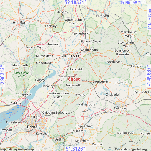
Stroud GPS coordinates[2]
51° 45' 0" North, 2° 12' 0" West
| Map corner | latitude | longitude |
|---|---|---|
| Upper-left | 52.18321°, | -2.90312° |
| Center: | 51.75°, | -2.2° |
| Lower-right: | 51.3126°, | -1.49687° |
| Map W x H: | 96.8×96.8 km | = 60.1×60.1mi |
| max Lat: | 60.39635° ⇑69.3% North |
| Stroud: | 51.75° |
| min Lat: | ⇓30.7% South 34.60088° |
| min Long | Stroud | max Long |
| -7.64133° | -2.2° | 32.95536° |
| W 40.8%⇐ | ⇒59.2% E |
Elevation
Elevation of Stroud is 83 m = 272 ft, and this is 10.1 m = 33 ft above average elevation for this country.
| Max E: |
515 m = 1690 ft | 36.4% |
| Stroud | 83 m 272 ft | |
| Avg. | 72.9 m = 239 ft | |
Min E: |
-30 m = -98 ft | 63.6% |
See also: Stroud elevation on elevation.city.
Geographical zone
Stroud is located in North temperate zone (between Tropic of Cancer and the Arctic Circle). Distance of this North polar circle is 1647.1 km =1023.5 mi to North.| Distance of | km | miles | from Stroud |
|---|---|---|---|
| North Pole | 4253 | 2642.7 | to North |
| Arctic Circle | 1647.1 | 1023.5 | to North |
| Tropic Cancer | 3148.1 | 1956.1 | to South |
| Equator | 5754.1 | 3575.4 | to South |


Nearby cities:
15 places around Stroud: (largest is in red/bold)
• Avening
8.1 km =5 mi,  164°
164°
• Barnwood
12.7 km =7.9 mi,  359°
359°
• Bisley
4.1 km =2.5 mi,  86°
86°
• Brimscombe
3.5 km =2.2 mi, 163°
• Chalford
4.3 km =2.7 mi,  128°
128°
• Coates
12.4 km =7.7 mi,  112°
112°
• Eastington
8.7 km =5.4 mi,  267°
267°
• Frampton on Severn
11.5 km =7.1 mi,  281°
281°
• Minchinhampton
4.9 km =3 mi,  167°
167°
• Nailsworth
6.4 km =4 mi,  192°
192°
• Painswick
4 km =2.5 mi,  4°
4°
• Slimbridge
12.5 km =7.8 mi,  260°
260°
• Stonehouse
5.7 km =3.5 mi, 270°
• Tetbury
12.6 km =7.8 mi, 168°
• Uley
10.3 km =6.4 mi,  224°
224°
Sources, notices
• [Note1] Compared only with cities in United Kingdom existing in our database
• [Src1] Map data: © OpenStreetMap contributors (CC-BY-SA)
• [Src2] Other city data from geonames.org with taken over terms of usage.
• [Src3] Geographical zone / Annual Mean Temperature by Robert A. Rohde @ Wikipedia
