Stratton-on-the-Fosse geodata
Stratton-on-the-Fosse (England) is a populated place; located in United Kingdom in Europe/London (GMT+0) time zone. With population of 995 people, there are 3645 cities with bigger population in this country. Compared to other cities in United Kingdom, 85.5% of cities are located further ↑North; 64.9% of cities are located further →East and 94.7% of cities have lower elevation than Stratton-on-the-Fosse. Note1
Administrative division(s):
- Level 1: England
- Level 2: Somerset
- Level 3: Mendip District
- Level 4: Stratton on the Fosse


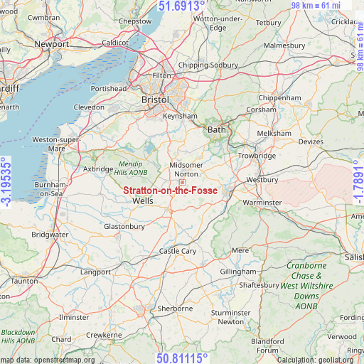
Stratton-on-the-Fosse GPS coordinates[2]
51° 15' 11.988" North, 2° 29' 31.992" West
| Map corner | latitude | longitude |
|---|---|---|
| Upper-left | 51.6913°, | -3.19535° |
| Center: | 51.25333°, | -2.49222° |
| Lower-right: | 50.81115°, | -1.7891° |
| Map W x H: | 97.9×97.9 km | = 60.8×60.8mi |
| max Lat: | 60.39635° ⇑85.5% North |
| Stratton-on-the-Fosse: | 51.25333° |
| min Lat: | ⇓14.5% South 34.60088° |
| min Long | Stratton-on-the | max Long |
| -7.64133° | -2.49222° | 32.95536° |
| W 35.1%⇐ | ⇒64.9% E |
Elevation
Elevation of Stratton-on-the-Fosse is 182 m = 597 ft, and this is 109.1 m = 358 ft above average elevation for this country.
| Max E: |
515 m = 1690 ft | 5.3% |
| Stratton-on-the-Fosse | 182 m 597 ft | |
| Avg. | 72.9 m = 239 ft | |
Min E: |
-30 m = -98 ft | 94.7% |
See also: United Kingdom elevation on elevation.city.
Geographical zone
Stratton-on-the-Fosse is located in North temperate zone (between Tropic of Cancer and the Arctic Circle). Distance of this North polar circle is 1702.3 km =1057.8 mi to North.| Distance of | km | miles | from Stratton-on-the-Fosse |
|---|---|---|---|
| North Pole | 4308.2 | 2677 | to North |
| Arctic Circle | 1702.3 | 1057.8 | to North |
| Tropic Cancer | 3092.9 | 1921.8 | to South |
| Equator | 5698.8 | 3541.1 | to South |


Nearby cities:
15 places around Stratton-on-the-Fosse: (largest is in red/bold)
• Cameley
8.5 km =5.3 mi,  325°
325°
• Camerton
7.4 km =4.6 mi,  19°
19°
• Chilcompton
1.5 km =0.9 mi,  322°
322°
• Croscombe
9.2 km =5.7 mi,  226°
226°
• Farrington Gurney
5.6 km =3.5 mi, 332°
• Holcombe
1.6 km =1 mi,  118°
118°
• Mells
7.2 km =4.5 mi,  101°
101°
• Midsomer Norton
3.6 km =2.2 mi,  6°
6°
• Oakhill
4.1 km =2.5 mi,  215°
215°
• Paulton
5.7 km =3.5 mi,  354°
354°
• Peasedown Saint John
8.5 km =5.3 mi,  33°
33°
• Radstock
4.5 km =2.8 mi, 29°
• Shepton Mallet
8 km =5 mi,  208°
208°
• Stoke St Michael
3.7 km =2.3 mi,  169°
169°
• Timsbury
8 km =5 mi, 6°
Sources, notices
• [Note1] Compared only with cities in United Kingdom existing in our database
• [Src1] Map data: © OpenStreetMap contributors (CC-BY-SA)
• [Src2] Other city data from geonames.org with taken over terms of usage.
• [Src3] Geographical zone / Annual Mean Temperature by Robert A. Rohde @ Wikipedia
