Stradbroke geodata
Stradbroke (England) is a populated place; located in United Kingdom in Europe/London (GMT+1) time zone. With population of 1,089 people, there are 3517 cities with bigger population in this country. Compared to other cities in United Kingdom, 53.6% of cities are located further ↑North; 98.3% of cities are located further ←West and 53% of cities have higher elevation than Stradbroke. Note1
Administrative division(s):
- Level 1: England
- Level 2: Suffolk
- Level 3: Mid Suffolk District
- Level 4: Stradbroke


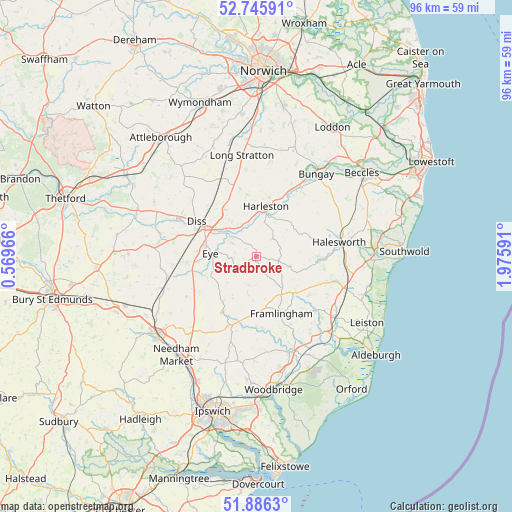
Stradbroke GPS coordinates[2]
52° 19' 5.484" North, 1° 16' 22.008" East
| Map corner | latitude | longitude |
|---|---|---|
| Upper-left | 52.74591°, | 0.56966° |
| Center: | 52.31819°, | 1.27278° |
| Lower-right: | 51.8863°, | 1.97591° |
| Map W x H: | 95.6×95.6 km | = 59.4×59.4mi |
| max Lat: | 60.39635° ⇑53.6% North |
| Stradbroke: | 52.31819° |
| min Lat: | ⇓46.4% South 34.60088° |
| min Long | Stradbroke | max Long |
| -7.64133° | 1.27278° | 32.95536° |
| W 98.3%⇐ | ⇒1.7% E |
Elevation
Elevation of Stradbroke is 56 m = 184 ft, and this is 16.9 m = 55 ft below average elevation for this country.
| Max E: |
515 m = 1690 ft | 53% |
| Avg. | 72.9 m = 239 ft | |
| Stradbroke | 56 m = 184 ft | |
Min E: |
-30 m = -98 ft | 47% |
See also: United Kingdom elevation on elevation.city.
Geographical zone
Stradbroke is located in North temperate zone (between Tropic of Cancer and the Arctic Circle). Distance of this North polar circle is 1583.9 km =984.2 mi to North.| Distance of | km | miles | from Stradbroke |
|---|---|---|---|
| North Pole | 4189.8 | 2603.4 | to North |
| Arctic Circle | 1583.9 | 984.2 | to North |
| Tropic Cancer | 3211.3 | 1995.4 | to South |
| Equator | 5817.2 | 3614.6 | to South |


Nearby cities:
15 places around Stradbroke: (largest is in red/bold)
• Burston
13.1 km =8.1 mi,  317°
317°
• Cookley
12 km =7.5 mi,  90°
90°
• Debenham
12.1 km =7.5 mi,  210°
210°
• Dickleburgh
10.6 km =6.6 mi,  325°
325°
• Diss
12.9 km =8 mi,  300°
300°
• Framlingham
11.8 km =7.3 mi,  156°
156°
• Fressingfield
4.5 km =2.8 mi,  43°
43°
• Harleston
9.6 km =6 mi,  9°
9°
• Laxfield
6.6 km =4.1 mi,  105°
105°
• Occold
8.2 km =5.1 mi,  250°
250°
• Pulham Market
12.7 km =7.9 mi,  346°
346°
• Pulham St Mary
11.8 km =7.3 mi, 352°
• Scole
9.6 km =6 mi, 304°
• Thorndon
10.2 km =6.3 mi, 247°
• Worlingworth
5.6 km =3.5 mi,  193°
193°
Sources, notices
• [Note1] Compared only with cities in United Kingdom existing in our database
• [Src1] Map data: © OpenStreetMap contributors (CC-BY-SA)
• [Src2] Other city data from geonames.org with taken over terms of usage.
• [Src3] Geographical zone / Annual Mean Temperature by Robert A. Rohde @ Wikipedia
