Stockport geodata
Stockport (England) is a seat of a second-order administrative division; located in United Kingdom in Europe/London (GMT+1) time zone. With population of 139,052 people, there are 68 cities with bigger population in this country. Compared to other cities in United Kingdom, 68% of cities are located further ↓South; 58.1% of cities are located further →East and 51.2% of cities have higher elevation than Stockport. Note1


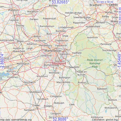
Stockport GPS coordinates[2]
53° 24' 35.244" North, 2° 9' 27.396" West
| Map corner | latitude | longitude |
|---|---|---|
| Upper-left | 53.82685°, | -2.86074° |
| Center: | 53.40979°, | -2.15761° |
| Lower-right: | 52.9886°, | -1.45449° |
| Map W x H: | 93.2×93.2 km | = 57.9×57.9mi |
| max Lat: | 60.39635° ⇑32% North |
| Stockport: | 53.40979° |
| min Lat: | ⇓68% South 34.60088° |
| min Long | Stockport | max Long |
| -7.64133° | -2.15761° | 32.95536° |
| W 41.9%⇐ | ⇒58.1% E |
Elevation
Elevation of Stockport is 59 m = 194 ft, and this is 13.9 m = 46 ft below average elevation for this country.
| Max E: |
515 m = 1690 ft | 51.2% |
| Avg. | 72.9 m = 239 ft | |
| Stockport | 59 m = 194 ft | |
Min E: |
-30 m = -98 ft | 48.8% |
See also: Stockport elevation on elevation.city.
Geographical zone
Stockport is located in North temperate zone (between Tropic of Cancer and the Arctic Circle). Distance of this North polar circle is 1462.6 km =908.8 mi to North.| Distance of | km | miles | from Stockport |
|---|---|---|---|
| North Pole | 4068.4 | 2528 | to North |
| Arctic Circle | 1462.6 | 908.8 | to North |
| Tropic Cancer | 3332.7 | 2070.8 | to South |
| Equator | 5938.6 | 3690.1 | to South |


Nearby cities:
15 places around Stockport: (largest is in red/bold)
• Bramhall
5.8 km =3.6 mi,  185°
185°
• Bredbury
2.8 km =1.7 mi,  74°
74°
• Burnage
3.8 km =2.4 mi,  312°
312°
• Cheadle Heath
2.4 km =1.5 mi,  248°
248°
• Cheadle Hulme
4.3 km =2.7 mi,  209°
209°
• Denton
5.8 km =3.6 mi,  26°
26°
• Didsbury
5 km =3.1 mi,  279°
279°
• Fallowfield
5.1 km =3.2 mi, 310°
• Haughton Green
5.3 km =3.3 mi,  48°
48°
• Hazel Grove
4 km =2.5 mi,  137°
137°
• Heaton Chapel
2.6 km =1.6 mi,  332°
332°
• Hyde
6.9 km =4.3 mi, 48°
• Longsight
6.1 km =3.8 mi, 331°
• Marple
6.5 km =4 mi,  105°
105°
• Poynton
7.2 km =4.5 mi,  157°
157°
Sources, notices
• [Note1] Compared only with cities in United Kingdom existing in our database
• [Src1] Map data: © OpenStreetMap contributors (CC-BY-SA)
• [Src2] Other city data from geonames.org with taken over terms of usage.
• [Src3] Geographical zone / Annual Mean Temperature by Robert A. Rohde @ Wikipedia
