Stanbridge geodata
Stanbridge (England) is a seat of a third-order administrative division; located in United Kingdom in Europe/London (GMT+1) time zone. With population of 1,044 people, there are 3569 cities with bigger population in this country. Compared to other cities in United Kingdom, 64.7% of cities are located further ↑North; 74.6% of cities are located further ←West and 77.2% of cities have lower elevation than Stanbridge. Note1


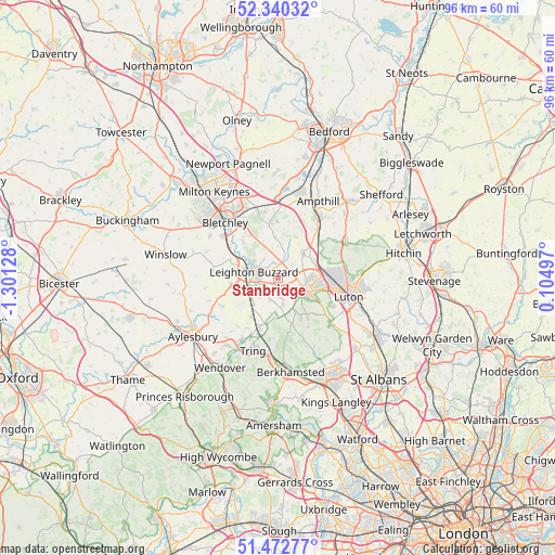
Stanbridge GPS coordinates[2]
51° 54' 31.104" North, 0° 35' 53.34" West
| Map corner | latitude | longitude |
|---|---|---|
| Upper-left | 52.34032°, | -1.30128° |
| Center: | 51.90864°, | -0.59815° |
| Lower-right: | 51.47277°, | 0.10497° |
| Map W x H: | 96.5×96.5 km | = 60×60mi |
| max Lat: | 60.39635° ⇑64.7% North |
| Stanbridge: | 51.90864° |
| min Lat: | ⇓35.3% South 34.60088° |
| min Long | Stanbridge | max Long |
| -7.64133° | -0.59815° | 32.95536° |
| W 74.6%⇐ | ⇒25.4% E |
Elevation
Elevation of Stanbridge is 111 m = 364 ft, and this is 38.1 m = 125 ft above average elevation for this country.
| Max E: |
515 m = 1690 ft | 22.8% |
| Stanbridge | 111 m 364 ft | |
| Avg. | 72.9 m = 239 ft | |
Min E: |
-30 m = -98 ft | 77.2% |
See also: United Kingdom elevation on elevation.city.
Geographical zone
Stanbridge is located in North temperate zone (between Tropic of Cancer and the Arctic Circle). Distance of this North polar circle is 1629.5 km =1012.5 mi to North.| Distance of | km | miles | from Stanbridge |
|---|---|---|---|
| North Pole | 4235.4 | 2631.8 | to North |
| Arctic Circle | 1629.5 | 1012.5 | to North |
| Tropic Cancer | 3165.8 | 1967.1 | to South |
| Equator | 5771.7 | 3586.4 | to South |


Nearby cities:
15 places around Stanbridge: (largest is in red/bold)
• Battlesden
4.4 km =2.7 mi,  2°
2°
• Chalgrave
5.2 km =3.2 mi,  55°
55°
• Chalton
7 km =4.3 mi,  72°
72°
• Cheddington
8.1 km =5 mi,  213°
213°
• Church End, Eversholt
8.4 km =5.2 mi,  13°
13°
• Dunstable
5.8 km =3.6 mi,  116°
116°
• Eaton Bray
3.5 km =2.2 mi,  172°
172°
• Heath and Reach
5.7 km =3.5 mi,  315°
315°
• Hockliffe
2.6 km =1.6 mi,  17°
17°
• Houghton Regis
5.3 km =3.3 mi,  95°
95°
• Leighton Buzzard
4.2 km =2.6 mi,  283°
283°
• Milton Bryan
4.7 km =2.9 mi, 12°
• Potsgrove
5.8 km =3.6 mi,  346°
346°
• Toddington
6.4 km =4 mi,  44°
44°
• Totternhoe
3.1 km =1.9 mi,  146°
146°
Sources, notices
• [Note1] Compared only with cities in United Kingdom existing in our database
• [Src1] Map data: © OpenStreetMap contributors (CC-BY-SA)
• [Src2] Other city data from geonames.org with taken over terms of usage.
• [Src3] Geographical zone / Annual Mean Temperature by Robert A. Rohde @ Wikipedia
