Staines geodata
Staines (England) is a populated place; located in United Kingdom in Europe/London (GMT+1) time zone. With population of 51,040 people, there are 227 cities with bigger population in this country. Compared to other cities in United Kingdom, 80% of cities are located further ↑North; 76.6% of cities are located further ←West and 84.7% of cities have higher elevation than Staines. Note1


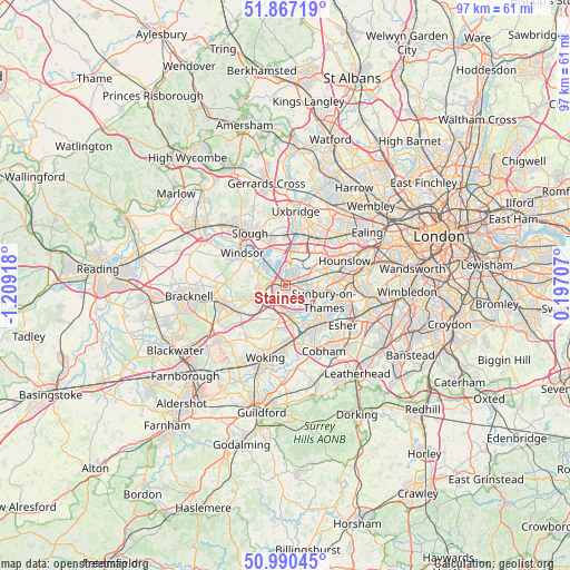
Staines GPS coordinates[2]
51° 25' 51.312" North, 0° 30' 21.816" West
| Map corner | latitude | longitude |
|---|---|---|
| Upper-left | 51.86719°, | -1.20918° |
| Center: | 51.43092°, | -0.50606° |
| Lower-right: | 50.99045°, | 0.19707° |
| Map W x H: | 97.5×97.5 km | = 60.6×60.6mi |
| max Lat: | 60.39635° ⇑80% North |
| Staines: | 51.43092° |
| min Lat: | ⇓20% South 34.60088° |
| min Long | Staines | max Long |
| -7.64133° | -0.50606° | 32.95536° |
| W 76.6%⇐ | ⇒23.4% E |
Elevation
Elevation of Staines is 16 m = 52 ft, and this is 56.9 m = 187 ft below average elevation for this country.
| Max E: |
515 m = 1690 ft | 84.7% |
| Avg. | 72.9 m = 239 ft | |
| Staines | 16 m = 52 ft | |
Min E: |
-30 m = -98 ft | 15.3% |
See also: Staines elevation on elevation.city.
Geographical zone
Staines is located in North temperate zone (between Tropic of Cancer and the Arctic Circle). Distance of this North polar circle is 1682.6 km =1045.5 mi to North.| Distance of | km | miles | from Staines |
|---|---|---|---|
| North Pole | 4288.5 | 2664.7 | to North |
| Arctic Circle | 1682.6 | 1045.5 | to North |
| Tropic Cancer | 3112.7 | 1934.1 | to South |
| Equator | 5718.6 | 3553.4 | to South |


Nearby cities:
15 places around Staines: (largest is in red/bold)
• Addlestone
6.7 km =4.2 mi,  172°
172°
• Ashford
3.4 km =2.1 mi,  88°
88°
• Chertsey
4.8 km =3 mi,  181°
181°
• Colnbrook
6 km =3.7 mi,  349°
349°
• Egham
3.2 km =2 mi,  271°
271°
• Feltham
6.6 km =4.1 mi,  75°
75°
• Harmondsworth
6.7 km =4.2 mi,  17°
17°
• Horton
5.3 km =3.3 mi,  331°
331°
• Iver
7.7 km =4.8 mi,  3°
3°
• Old Windsor
6.4 km =4 mi,  298°
298°
• Ottershaw
7.7 km =4.8 mi,  191°
191°
• Shepperton
5.6 km =3.5 mi,  134°
134°
• Sunbury-on-Thames
6.8 km =4.2 mi,  115°
115°
• Virginia Water
5.2 km =3.2 mi,  233°
233°
• Weybridge
7.3 km =4.5 mi,  153°
153°
Sources, notices
• [Note1] Compared only with cities in United Kingdom existing in our database
• [Src1] Map data: © OpenStreetMap contributors (CC-BY-SA)
• [Src2] Other city data from geonames.org with taken over terms of usage.
• [Src3] Geographical zone / Annual Mean Temperature by Robert A. Rohde @ Wikipedia
