South Kelsey geodata
South Kelsey (England) is a populated place; located in United Kingdom in Europe/London (GMT+0) time zone. With population of 604 people, there are 4560 cities with bigger population in this country. Compared to other cities in United Kingdom, 69.2% of cities are located further ↓South; 78.2% of cities are located further ←West and 77.1% of cities have higher elevation than South Kelsey. Note1
Administrative division(s):
- Level 1: England
- Level 2: Lincolnshire
- Level 3: West Lindsey District
- Level 4: South Kelsey


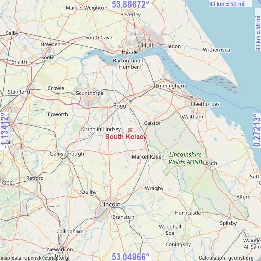
South Kelsey GPS coordinates[2]
53° 28' 12.9" North, 0° 25' 51.564" West
| Map corner | latitude | longitude |
|---|---|---|
| Upper-left | 53.88672°, | -1.13412° |
| Center: | 53.47025°, | -0.43099° |
| Lower-right: | 53.04966°, | 0.27213° |
| Map W x H: | 93.1×93.1 km | = 57.8×57.8mi |
| max Lat: | 60.39635° ⇑30.8% North |
| South Kelsey: | 53.47025° |
| min Lat: | ⇓69.2% South 34.60088° |
| min Long | South Kelsey | max Long |
| -7.64133° | -0.43099° | 32.95536° |
| W 78.2%⇐ | ⇒21.8% E |
Elevation
Elevation of South Kelsey is 24 m = 79 ft, and this is 48.9 m = 160 ft below average elevation for this country.
| Max E: |
515 m = 1690 ft | 77.1% |
| Avg. | 72.9 m = 239 ft | |
| South Kelsey | 24 m = 79 ft | |
Min E: |
-30 m = -98 ft | 22.9% |
See also: United Kingdom elevation on elevation.city.
Geographical zone
South Kelsey is located in North temperate zone (between Tropic of Cancer and the Arctic Circle). Distance of this North polar circle is 1455.8 km =904.6 mi to North.| Distance of | km | miles | from South Kelsey |
|---|---|---|---|
| North Pole | 4061.7 | 2523.8 | to North |
| Arctic Circle | 1455.8 | 904.6 | to North |
| Tropic Cancer | 3339.4 | 2075 | to South |
| Equator | 5945.3 | 3694.2 | to South |


Nearby cities:
15 places around South Kelsey: (largest is in red/bold)
• Barnetby le Wold
11.7 km =7.3 mi,  8°
8°
• Brigg
9.9 km =6.2 mi,  336°
336°
• Caistor
8.2 km =5.1 mi,  68°
68°
• Glentham
8.9 km =5.5 mi,  208°
208°
• Hibaldstow
7.5 km =4.7 mi,  307°
307°
• Kirton in Lindsey
10.9 km =6.8 mi,  273°
273°
• Manton
11.8 km =7.3 mi,  294°
294°
• Market Rasen
11.1 km =6.9 mi,  146°
146°
• Middle Rasen
10.3 km =6.4 mi, 153°
• Nettleton
6.8 km =4.2 mi,  75°
75°
• North Kelsey
3.7 km =2.3 mi, 5°
• Redbourne
7.2 km =4.5 mi, 285°
• Scawby
10.5 km =6.5 mi,  315°
315°
• Waddingham
6.2 km =3.9 mi,  252°
252°
• Wrawby
10.9 km =6.8 mi,  349°
349°
Sources, notices
• [Note1] Compared only with cities in United Kingdom existing in our database
• [Src1] Map data: © OpenStreetMap contributors (CC-BY-SA)
• [Src2] Other city data from geonames.org with taken over terms of usage.
• [Src3] Geographical zone / Annual Mean Temperature by Robert A. Rohde @ Wikipedia
