South Creake geodata
South Creake (England) is a populated place; located in United Kingdom in Europe/London (GMT+0) time zone. With population of 516 people, there are 4841 cities with bigger population in this country. Compared to other cities in United Kingdom, 58.8% of cities are located further ↓South; 94.7% of cities are located further ←West and 74.7% of cities have higher elevation than South Creake. Note1
Administrative division(s):
- Level 1: England
- Level 2: Norfolk
- Level 3: King's Lynn and West Norfolk District
- Level 4: South Creake


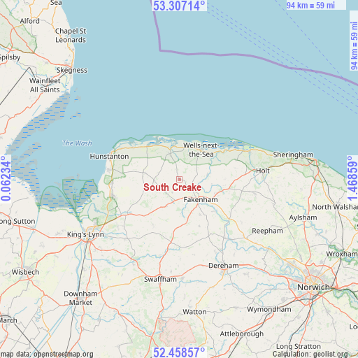
South Creake GPS coordinates[2]
52° 53' 5.748" North, 0° 45' 55.692" East
| Map corner | latitude | longitude |
|---|---|---|
| Upper-left | 53.30714°, | 0.06234° |
| Center: | 52.88493°, | 0.76547° |
| Lower-right: | 52.45857°, | 1.46859° |
| Map W x H: | 94.4×94.3 km | = 58.7×58.6mi |
| max Lat: | 60.39635° ⇑41.2% North |
| South Creake: | 52.88493° |
| min Lat: | ⇓58.8% South 34.60088° |
| min Long | South Creake | max Long |
| -7.64133° | 0.76547° | 32.95536° |
| W 94.7%⇐ | ⇒5.3% E |
Elevation
Elevation of South Creake is 27 m = 89 ft, and this is 45.9 m = 151 ft below average elevation for this country.
| Max E: |
515 m = 1690 ft | 74.7% |
| Avg. | 72.9 m = 239 ft | |
| South Creake | 27 m = 89 ft | |
Min E: |
-30 m = -98 ft | 25.3% |
See also: United Kingdom elevation on elevation.city.
Geographical zone
South Creake is located in North temperate zone (between Tropic of Cancer and the Arctic Circle). Distance of this North polar circle is 1520.9 km =945 mi to North.| Distance of | km | miles | from South Creake |
|---|---|---|---|
| North Pole | 4126.8 | 2564.3 | to North |
| Arctic Circle | 1520.9 | 945 | to North |
| Tropic Cancer | 3274.3 | 2034.6 | to South |
| Equator | 5880.3 | 3653.8 | to South |


Nearby cities:
15 places around South Creake: (largest is in red/bold)
• Burnham Market
7.2 km =4.5 mi,  338°
338°
• Colkirk
10.8 km =6.7 mi,  149°
149°
• Dersingham
18.1 km =11.2 mi,  256°
256°
• Docking
9.6 km =6 mi,  280°
280°
• East Rudham
8 km =5 mi,  207°
207°
• Fakenham
8.2 km =5.1 mi,  137°
137°
• Great Massingham
14 km =8.7 mi, 209°
• Great Ryburgh
12.5 km =7.8 mi,  133°
133°
• Heacham
18.4 km =11.4 mi, 277°
• Hindolveston
18.4 km =11.4 mi,  111°
111°
• Little Walsingham
7.4 km =4.6 mi,  81°
81°
• Mileham
17 km =10.6 mi,  164°
164°
• Sedgeford
14.9 km =9.3 mi, 276°
• Snettisham
17.8 km =11.1 mi,  267°
267°
• Wells-next-the-Sea
9.4 km =5.8 mi,  37°
37°
Sources, notices
• [Note1] Compared only with cities in United Kingdom existing in our database
• [Src1] Map data: © OpenStreetMap contributors (CC-BY-SA)
• [Src2] Other city data from geonames.org with taken over terms of usage.
• [Src3] Geographical zone / Annual Mean Temperature by Robert A. Rohde @ Wikipedia
