Solihull geodata
Solihull (England) is a seat of a second-order administrative division; located in United Kingdom in Europe/London (GMT+0) time zone. With population of 96,267 people, there are 100 cities with bigger population in this country. Compared to other cities in United Kingdom, 51.4% of cities are located further ↑North; 50.7% of cities are located further →East and 84.8% of cities have lower elevation than Solihull. Note1


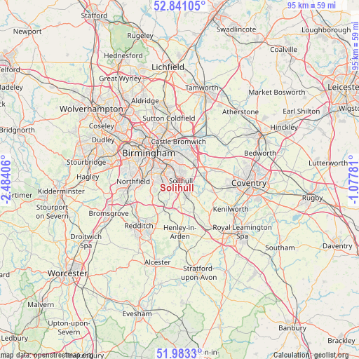
Solihull GPS coordinates[2]
52° 24' 51.336" North, 1° 46' 51.384" West
| Map corner | latitude | longitude |
|---|---|---|
| Upper-left | 52.84105°, | -2.48406° |
| Center: | 52.41426°, | -1.78094° |
| Lower-right: | 51.9833°, | -1.07781° |
| Map W x H: | 95.4×95.4 km | = 59.3×59.3mi |
| max Lat: | 60.39635° ⇑51.4% North |
| Solihull: | 52.41426° |
| min Lat: | ⇓48.6% South 34.60088° |
| min Long | Solihull | max Long |
| -7.64133° | -1.78094° | 32.95536° |
| W 49.3%⇐ | ⇒50.7% E |
Elevation
Elevation of Solihull is 132 m = 433 ft, and this is 59.1 m = 194 ft above average elevation for this country.
| Max E: |
515 m = 1690 ft | 15.2% |
| Solihull | 132 m 433 ft | |
| Avg. | 72.9 m = 239 ft | |
Min E: |
-30 m = -98 ft | 84.8% |
See also: Solihull elevation on elevation.city.
Geographical zone
Solihull is located in North temperate zone (between Tropic of Cancer and the Arctic Circle). Distance of this North polar circle is 1573.3 km =977.6 mi to North.| Distance of | km | miles | from Solihull |
|---|---|---|---|
| North Pole | 4179.1 | 2596.8 | to North |
| Arctic Circle | 1573.3 | 977.6 | to North |
| Tropic Cancer | 3222 | 2002.1 | to South |
| Equator | 5827.9 | 3621.3 | to South |


Nearby cities:
15 places around Solihull: (largest is in red/bold)
• Acocks Green
4.7 km =2.9 mi,  328°
328°
• Balsall Common
9.2 km =5.7 mi,  105°
105°
• Barston
6 km =3.7 mi, 105°
• Berkswell
9.4 km =5.8 mi,  93°
93°
• Bickenhill
4.7 km =2.9 mi,  53°
53°
• Chelmsley Wood
7.7 km =4.8 mi,  22°
22°
• Cheswick Green
4.4 km =2.7 mi,  210°
210°
• Dickens Heath
5.1 km =3.2 mi,  231°
231°
• Dorridge
5 km =3.1 mi,  157°
157°
• Earlswood
6.4 km =4 mi, 213°
• Hampton in Arden
5.4 km =3.4 mi,  76°
76°
• Hockley Heath
6.8 km =4.2 mi,  178°
178°
• Knowle
4.7 km =2.9 mi,  136°
136°
• Shirley
2.6 km =1.6 mi,  261°
261°
• Tidbury Green
6.3 km =3.9 mi, 234°
Sources, notices
• [Note1] Compared only with cities in United Kingdom existing in our database
• [Src1] Map data: © OpenStreetMap contributors (CC-BY-SA)
• [Src2] Other city data from geonames.org with taken over terms of usage.
• [Src3] Geographical zone / Annual Mean Temperature by Robert A. Rohde @ Wikipedia
