Shouldham geodata
Shouldham (England) is a populated place; located in United Kingdom in Europe/London (GMT+1) time zone. With population of 605 people, there are 4557 cities with bigger population in this country. Compared to other cities in United Kingdom, 53.9% of cities are located further ↓South; 92% of cities are located further ←West and 85.8% of cities have higher elevation than Shouldham. Note1
Administrative division(s):
- Level 1: England
- Level 2: Norfolk
- Level 3: King's Lynn and West Norfolk District
- Level 4: Shouldham


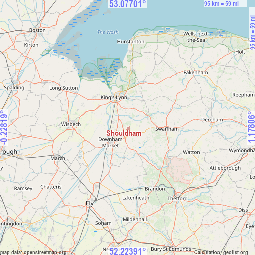
Shouldham GPS coordinates[2]
52° 39' 9.144" North, 0° 28' 29.784" East
| Map corner | latitude | longitude |
|---|---|---|
| Upper-left | 53.07701°, | -0.22819° |
| Center: | 52.65254°, | 0.47494° |
| Lower-right: | 52.22391°, | 1.17806° |
| Map W x H: | 94.9×94.9 km | = 59×59mi |
| max Lat: | 60.39635° ⇑46.1% North |
| Shouldham: | 52.65254° |
| min Lat: | ⇓53.9% South 34.60088° |
| min Long | Shouldham | max Long |
| -7.64133° | 0.47494° | 32.95536° |
| W 92%⇐ | ⇒8% E |
Elevation
Elevation of Shouldham is 15 m = 49 ft, and this is 57.9 m = 190 ft below average elevation for this country.
| Max E: |
515 m = 1690 ft | 85.8% |
| Avg. | 72.9 m = 239 ft | |
| Shouldham | 15 m = 49 ft | |
Min E: |
-30 m = -98 ft | 14.2% |
See also: United Kingdom elevation on elevation.city.
Geographical zone
Shouldham is located in North temperate zone (between Tropic of Cancer and the Arctic Circle). Distance of this North polar circle is 1546.8 km =961.1 mi to North.| Distance of | km | miles | from Shouldham |
|---|---|---|---|
| North Pole | 4152.6 | 2580.3 | to North |
| Arctic Circle | 1546.8 | 961.1 | to North |
| Tropic Cancer | 3248.5 | 2018.5 | to South |
| Equator | 5854.4 | 3637.8 | to South |


Nearby cities:
15 places around Shouldham: (largest is in red/bold)
• Clenchwarton
14 km =8.7 mi,  325°
325°
• Downham Market
8 km =5 mi,  230°
230°
• East Winch
8 km =5 mi,  18°
18°
• Grimston
14.3 km =8.9 mi, 20°
• Hilgay
11.8 km =7.3 mi,  209°
209°
• King's Lynn
12.3 km =7.6 mi, 334°
• Marham
3.2 km =2 mi,  76°
76°
• Narborough
8.1 km =5 mi,  64°
64°
• Northwold
14.1 km =8.8 mi,  148°
148°
• Runcton Holme
5.8 km =3.6 mi,  272°
272°
• Stoke Ferry
9.5 km =5.9 mi,  164°
164°
• Swaffham
14.2 km =8.8 mi,  92°
92°
• Terrington Saint John
14.8 km =9.2 mi,  293°
293°
• Wereham
7.4 km =4.6 mi,  176°
176°
• Wimbotsham
6.9 km =4.3 mi,  237°
237°
Sources, notices
• [Note1] Compared only with cities in United Kingdom existing in our database
• [Src1] Map data: © OpenStreetMap contributors (CC-BY-SA)
• [Src2] Other city data from geonames.org with taken over terms of usage.
• [Src3] Geographical zone / Annual Mean Temperature by Robert A. Rohde @ Wikipedia
