Shildon geodata
Shildon (England) is a populated place; located in United Kingdom in Europe/London (GMT+1) time zone. With population of 9,976 people, there are 1059 cities with bigger population in this country. Compared to other cities in United Kingdom, 83.5% of cities are located further ↓South; 52.1% of cities are located further ←West and 84.8% of cities have lower elevation than Shildon. Note1


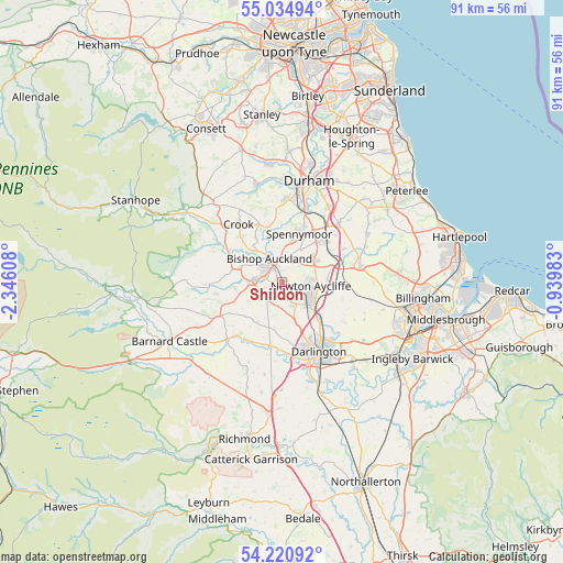
Shildon GPS coordinates[2]
54° 37' 47.892" North, 1° 38' 34.62" West
| Map corner | latitude | longitude |
|---|---|---|
| Upper-left | 55.03494°, | -2.34608° |
| Center: | 54.62997°, | -1.64295° |
| Lower-right: | 54.22092°, | -0.93983° |
| Map W x H: | 90.5×90.5 km | = 56.2×56.2mi |
| max Lat: | 60.39635° ⇑16.5% North |
| Shildon: | 54.62997° |
| min Lat: | ⇓83.5% South 34.60088° |
| min Long | Shildon | max Long |
| -7.64133° | -1.64295° | 32.95536° |
| W 52.1%⇐ | ⇒47.9% E |
Elevation
Elevation of Shildon is 132 m = 433 ft, and this is 59.1 m = 194 ft above average elevation for this country.
| Max E: |
515 m = 1690 ft | 15.2% |
| Shildon | 132 m 433 ft | |
| Avg. | 72.9 m = 239 ft | |
Min E: |
-30 m = -98 ft | 84.8% |
See also: United Kingdom elevation on elevation.city.
Geographical zone
Shildon is located in North temperate zone (between Tropic of Cancer and the Arctic Circle). Distance of this North polar circle is 1326.9 km =824.5 mi to North.| Distance of | km | miles | from Shildon |
|---|---|---|---|
| North Pole | 3932.8 | 2443.7 | to North |
| Arctic Circle | 1326.9 | 824.5 | to North |
| Tropic Cancer | 3468.4 | 2155.2 | to South |
| Equator | 6074.3 | 3774.4 | to South |


Nearby cities:
15 places around Shildon: (largest is in red/bold)
• Bishop Auckland
3.6 km =2.2 mi,  322°
322°
• Byers Green
7.8 km =4.8 mi,  355°
355°
• Coatham Mundeville
7.9 km =4.9 mi,  134°
134°
• Coundon
3.8 km =2.4 mi,  15°
15°
• Denton
7.2 km =4.5 mi,  192°
192°
• Evenwood
7.7 km =4.8 mi,  263°
263°
• Heighington
4.1 km =2.5 mi,  156°
156°
• High Etherley
7 km =4.3 mi,  292°
292°
• Hunwick
7.6 km =4.7 mi,  328°
328°
• Kirk Merrington
5.9 km =3.7 mi,  29°
29°
• Low Etherley
7 km =4.3 mi, 292°
• Newton Aycliffe
4.8 km =3 mi,  105°
105°
• Spennymoor
8.1 km =5 mi, 18°
• Summerhouse
7.6 km =4.7 mi,  203°
203°
• Walworth
7.1 km =4.4 mi,  183°
183°
Sources, notices
• [Note1] Compared only with cities in United Kingdom existing in our database
• [Src1] Map data: © OpenStreetMap contributors (CC-BY-SA)
• [Src2] Other city data from geonames.org with taken over terms of usage.
• [Src3] Geographical zone / Annual Mean Temperature by Robert A. Rohde @ Wikipedia
