Rugby geodata
Rugby (England) is a populated place; located in United Kingdom in Europe/London (GMT+1) time zone. With population of 73,150 people, there are 143 cities with bigger population in this country. Compared to other cities in United Kingdom, 52.3% of cities are located further ↑North; 61.4% of cities are located further ←West and 80.9% of cities have lower elevation than Rugby. Note1


Rugby GPS coordinates[2]
52° 22' 15.312" North, 1° 15' 51.012" West
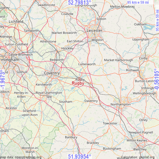
| Map corner | latitude | longitude |
|---|---|---|
| Upper-left | 52.79813°, | -1.9673° |
| Center: | 52.37092°, | -1.26417° |
| Lower-right: | 51.93954°, | -0.56105° |
| Map W x H: | 95.5×95.5 km | = 59.3×59.3mi |
| max Lat: | 60.39635° ⇑52.3% North |
| Rugby: | 52.37092° |
| min Lat: | ⇓47.7% South 34.60088° |
| min Long | Rugby | max Long |
| -7.64133° | -1.26417° | 32.95536° |
| W 61.4%⇐ | ⇒38.6% E |
Elevation
Elevation of Rugby is 120 m = 394 ft, and this is 47.1 m = 155 ft above average elevation for this country.
| Max E: |
515 m = 1690 ft | 19.1% |
| Rugby | 120 m 394 ft | |
| Avg. | 72.9 m = 239 ft | |
Min E: |
-30 m = -98 ft | 80.9% |
See also: Rugby elevation on elevation.city.
Geographical zone
Rugby is located in North temperate zone (between Tropic of Cancer and the Arctic Circle). Distance of this North polar circle is 1578.1 km =980.6 mi to North.| Distance of | km | miles | from Rugby |
|---|---|---|---|
| North Pole | 4184 | 2599.8 | to North |
| Arctic Circle | 1578.1 | 980.6 | to North |
| Tropic Cancer | 3217.2 | 1999.1 | to South |
| Equator | 5823.1 | 3618.3 | to South |


Nearby cities:
15 places around Rugby: (largest is in red/bold)
• Barby
6.2 km =3.9 mi,  139°
139°
• Brandon
9.3 km =5.8 mi,  279°
279°
• Braunston
9.9 km =6.2 mi,  155°
155°
• Brinklow
8.1 km =5 mi,  303°
303°
• Crick
9 km =5.6 mi,  106°
106°
• Dunchurch
4.1 km =2.5 mi,  206°
206°
• Kilsby
7.3 km =4.5 mi,  124°
124°
• Long Lawford
3.2 km =2 mi,  292°
292°
• Lutterworth
10.4 km =6.5 mi,  23°
23°
• Pailton
7.6 km =4.7 mi,  336°
336°
• Ryton on Dunsmore
11.5 km =7.1 mi,  267°
267°
• Swinford
8 km =5 mi,  56°
56°
• Ullesthorpe
12.6 km =7.8 mi,  3°
3°
• Wolston
8.9 km =5.5 mi, 274°
• Yelvertoft
9.7 km =6 mi,  88°
88°
Sources, notices
• [Note1] Compared only with cities in United Kingdom existing in our database
• [Src1] Map data: © OpenStreetMap contributors (CC-BY-SA)
• [Src2] Other city data from geonames.org with taken over terms of usage.
• [Src3] Geographical zone / Annual Mean Temperature by Robert A. Rohde @ Wikipedia
