Pointon geodata
Pointon (England) is a populated place; located in United Kingdom in Europe/London (GMT+1) time zone. With population of 532 people, there are 4793 cities with bigger population in this country. Compared to other cities in United Kingdom, 58.6% of cities are located further ↓South; 79.9% of cities are located further ←West and 91.2% of cities have higher elevation than Pointon. Note1
Administrative division(s):
- Level 1: England
- Level 2: Lincolnshire
- Level 3: South Kesteven District
- Level 4: Pointon and Sempringham


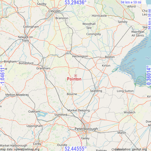
Pointon GPS coordinates[2]
52° 52' 19.308" North, 0° 20' 34.728" West
| Map corner | latitude | longitude |
|---|---|---|
| Upper-left | 53.29436°, | -1.04611° |
| Center: | 52.87203°, | -0.34298° |
| Lower-right: | 52.44555°, | 0.36014° |
| Map W x H: | 94.4×94.4 km | = 58.7×58.7mi |
| max Lat: | 60.39635° ⇑41.4% North |
| Pointon: | 52.87203° |
| min Lat: | ⇓58.6% South 34.60088° |
| min Long | Pointon | max Long |
| -7.64133° | -0.34298° | 32.95536° |
| W 79.9%⇐ | ⇒20.1% E |
Elevation
Elevation of Pointon is 11 m = 36 ft, and this is 61.9 m = 203 ft below average elevation for this country.
| Max E: |
515 m = 1690 ft | 91.2% |
| Avg. | 72.9 m = 239 ft | |
| Pointon | 11 m = 36 ft | |
Min E: |
-30 m = -98 ft | 8.8% |
See also: United Kingdom elevation on elevation.city.
Geographical zone
Pointon is located in North temperate zone (between Tropic of Cancer and the Arctic Circle). Distance of this North polar circle is 1522.4 km =946 mi to North.| Distance of | km | miles | from Pointon |
|---|---|---|---|
| North Pole | 4128.2 | 2565.1 | to North |
| Arctic Circle | 1522.4 | 946 | to North |
| Tropic Cancer | 3272.9 | 2033.7 | to South |
| Equator | 5878.8 | 3652.9 | to South |


Nearby cities:
15 places around Pointon: (largest is in red/bold)
• Bicker
12.3 km =7.6 mi,  63°
63°
• Billingborough
2.4 km =1.5 mi,  1°
1°
• Bourne
12 km =7.5 mi,  193°
193°
• Corby Glen
13.5 km =8.4 mi,  240°
240°
• Donington
9.9 km =6.2 mi,  68°
68°
• Folkingham
4.7 km =2.9 mi,  293°
293°
• Gosberton
12.2 km =7.6 mi,  91°
91°
• Heckington
12.6 km =7.8 mi,  13°
13°
• Helpringham
9.2 km =5.7 mi,  15°
15°
• Pinchbeck
13.8 km =8.6 mi,  118°
118°
• Quadring
10.8 km =6.7 mi,  83°
83°
• Rippingale
4.1 km =2.5 mi,  206°
206°
• Ropsley
12.6 km =7.8 mi,  282°
282°
• Sleaford
14.7 km =9.1 mi,  342°
342°
• Swineshead
14.8 km =9.2 mi, 56°
Sources, notices
• [Note1] Compared only with cities in United Kingdom existing in our database
• [Src1] Map data: © OpenStreetMap contributors (CC-BY-SA)
• [Src2] Other city data from geonames.org with taken over terms of usage.
• [Src3] Geographical zone / Annual Mean Temperature by Robert A. Rohde @ Wikipedia
