Peterborough geodata
Peterborough (England) is a seat of a second-order administrative division; located in United Kingdom in Europe/London (GMT+1) time zone. With population of 163,379 people, there are 54 cities with bigger population in this country. Compared to other cities in United Kingdom, 51.7% of cities are located further ↓South; 82% of cities are located further ←West and 89.9% of cities have higher elevation than Peterborough. Note1


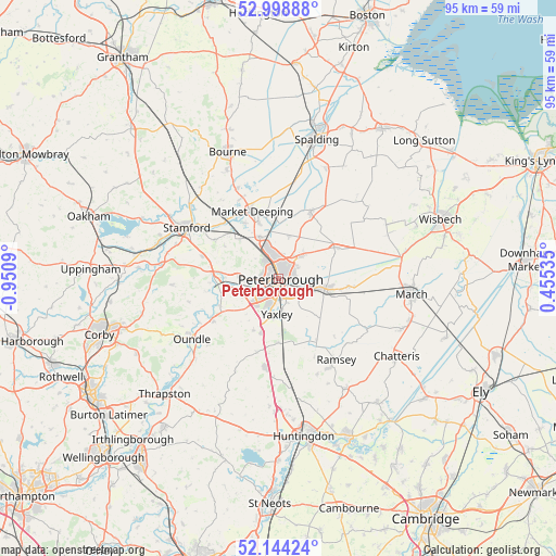
Peterborough GPS coordinates[2]
52° 34' 25.104" North, 0° 14' 51.972" West
| Map corner | latitude | longitude |
|---|---|---|
| Upper-left | 52.99888°, | -0.9509° |
| Center: | 52.57364°, | -0.24777° |
| Lower-right: | 52.14424°, | 0.45535° |
| Map W x H: | 95×95 km | = 59×59mi |
| max Lat: | 60.39635° ⇑48.3% North |
| Peterborough: | 52.57364° |
| min Lat: | ⇓51.7% South 34.60088° |
| min Long | Peterborough | max Long |
| -7.64133° | -0.24777° | 32.95536° |
| W 82%⇐ | ⇒18% E |
Elevation
Elevation of Peterborough is 12 m = 39 ft, and this is 60.9 m = 200 ft below average elevation for this country.
| Max E: |
515 m = 1690 ft | 89.9% |
| Avg. | 72.9 m = 239 ft | |
| Peterborough | 12 m = 39 ft | |
Min E: |
-30 m = -98 ft | 10.1% |
See also: Peterborough elevation on elevation.city.
Geographical zone
Peterborough is located in North temperate zone (between Tropic of Cancer and the Arctic Circle). Distance of this North polar circle is 1555.5 km =966.5 mi to North.| Distance of | km | miles | from Peterborough |
|---|---|---|---|
| North Pole | 4161.4 | 2585.8 | to North |
| Arctic Circle | 1555.5 | 966.5 | to North |
| Tropic Cancer | 3239.7 | 2013.1 | to South |
| Equator | 5845.6 | 3632.3 | to South |


Nearby cities:
15 places around Peterborough: (largest is in red/bold)
• Ailsworth
6.9 km =4.3 mi,  272°
272°
• Castor
6.6 km =4.1 mi, 269°
• Eye
5.4 km =3.4 mi,  44°
44°
• Folksworth
9.8 km =6.1 mi,  206°
206°
• Glinton
8 km =5 mi,  335°
335°
• Helpston
9.3 km =5.8 mi,  314°
314°
• Marholm
5.3 km =3.3 mi, 310°
• Newborough
7.4 km =4.6 mi,  12°
12°
• Northborough
10 km =6.2 mi, 340°
• Peakirk
8.2 km =5.1 mi,  348°
348°
• Stilton
9.9 km =6.2 mi,  196°
196°
• Thorney
10.8 km =6.7 mi,  60°
60°
• Upton
8.4 km =5.2 mi,  282°
282°
• Whittlesey
8.1 km =5 mi,  102°
102°
• Yaxley
6.3 km =3.9 mi,  186°
186°
Sources, notices
• [Note1] Compared only with cities in United Kingdom existing in our database
• [Src1] Map data: © OpenStreetMap contributors (CC-BY-SA)
• [Src2] Other city data from geonames.org with taken over terms of usage.
• [Src3] Geographical zone / Annual Mean Temperature by Robert A. Rohde @ Wikipedia
