Paisley geodata
Paisley (Scotland) is a seat of a second-order administrative division; located in United Kingdom in Europe/London (GMT+1) time zone. With population of 76,220 people, there are 133 cities with bigger population in this country. Compared to other cities in United Kingdom, 91.3% of cities are located further ↓South; 92.6% of cities are located further →East and 57.5% of cities have higher elevation than Paisley. Note1


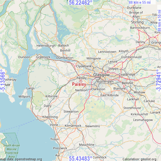
Paisley GPS coordinates[2]
55° 49' 54.228" North, 4° 25' 57.144" West
| Map corner | latitude | longitude |
|---|---|---|
| Upper-left | 56.22462°, | -5.13566° |
| Center: | 55.83173°, | -4.43254° |
| Lower-right: | 55.43483°, | -3.72941° |
| Map W x H: | 87.8×87.8 km | = 54.6×54.6mi |
| max Lat: | 60.39635° ⇑8.7% North |
| Paisley: | 55.83173° |
| min Lat: | ⇓91.3% South 34.60088° |
| min Long | Paisley | max Long |
| -7.64133° | -4.43254° | 32.95536° |
| W 7.4%⇐ | ⇒92.6% E |
Elevation
Elevation of Paisley is 50 m = 164 ft, and this is 22.9 m = 75 ft below average elevation for this country.
| Max E: |
515 m = 1690 ft | 57.5% |
| Avg. | 72.9 m = 239 ft | |
| Paisley | 50 m = 164 ft | |
Min E: |
-30 m = -98 ft | 42.5% |
See also: Paisley elevation on elevation.city.
Geographical zone
Paisley is located in North temperate zone (between Tropic of Cancer and the Arctic Circle). Distance of this North polar circle is 1193.3 km =741.5 mi to North.| Distance of | km | miles | from Paisley |
|---|---|---|---|
| North Pole | 3799.2 | 2360.7 | to North |
| Arctic Circle | 1193.3 | 741.5 | to North |
| Tropic Cancer | 3602 | 2238.2 | to South |
| Equator | 6207.9 | 3857.4 | to South |


Nearby cities:
15 places around Paisley: (largest is in red/bold)
• Barrhead
4.4 km =2.7 mi,  145°
145°
• Brookfield
6.6 km =4.1 mi,  284°
284°
• Clydebank
7.9 km =4.9 mi,  12°
12°
• Elderslie
3.3 km =2.1 mi,  272°
272°
• Erskine
7.7 km =4.8 mi,  351°
351°
• Hawkhead
3.1 km =1.9 mi,  86°
86°
• Howwood
8.1 km =5 mi,  253°
253°
• Inchinnan
6.5 km =4 mi,  356°
356°
• Johnstone
5.2 km =3.2 mi, 266°
• Kilbarchan
7.6 km =4.7 mi, 273°
• Linwood
4.2 km =2.6 mi,  295°
295°
• Neilston
5.1 km =3.2 mi,  175°
175°
• Renfrew
5.1 km =3.2 mi,  29°
29°
• Thornliebank
7.8 km =4.8 mi,  112°
112°
• Uplawmoor
8.4 km =5.2 mi,  208°
208°
Sources, notices
• [Note1] Compared only with cities in United Kingdom existing in our database
• [Src1] Map data: © OpenStreetMap contributors (CC-BY-SA)
• [Src2] Other city data from geonames.org with taken over terms of usage.
• [Src3] Geographical zone / Annual Mean Temperature by Robert A. Rohde @ Wikipedia
