Oxford geodata
Oxford (England) is a seat of a second-order administrative division; located in United Kingdom in Europe/London (GMT+1) time zone. With population of 171,380 people, there are 50 cities with bigger population in this country. Compared to other cities in United Kingdom, 69.2% of cities are located further ↑North; 61.5% of cities are located further ←West and 57.1% of cities have lower elevation than Oxford. Note1


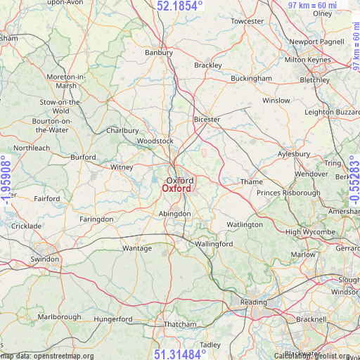
Oxford GPS coordinates[2]
51° 45' 7.992" North, 1° 15' 21.456" West
| Map corner | latitude | longitude |
|---|---|---|
| Upper-left | 52.1854°, | -1.95908° |
| Center: | 51.75222°, | -1.25596° |
| Lower-right: | 51.31484°, | -0.55283° |
| Map W x H: | 96.8×96.8 km | = 60.1×60.1mi |
| max Lat: | 60.39635° ⇑69.2% North |
| Oxford: | 51.75222° |
| min Lat: | ⇓30.8% South 34.60088° |
| min Long | Oxford | max Long |
| -7.64133° | -1.25596° | 32.95536° |
| W 61.5%⇐ | ⇒38.5% E |
Elevation
Elevation of Oxford is 72 m = 236 ft, and this is 0.90000000000001 m = 3 ft below average elevation for this country.
| Max E: |
515 m = 1690 ft | 42.9% |
| Avg. | 72.9 m = 239 ft | |
| Oxford | 72 m = 236 ft | |
Min E: |
-30 m = -98 ft | 57.1% |
See also: Oxford elevation on elevation.city.
Geographical zone
Oxford is located in North temperate zone (between Tropic of Cancer and the Arctic Circle). Distance of this North polar circle is 1646.9 km =1023.3 mi to North.| Distance of | km | miles | from Oxford |
|---|---|---|---|
| North Pole | 4252.8 | 2642.6 | to North |
| Arctic Circle | 1646.9 | 1023.3 | to North |
| Tropic Cancer | 3148.4 | 1956.3 | to South |
| Equator | 5754.3 | 3575.6 | to South |


Nearby cities:
15 places around Oxford: (largest is in red/bold)
• Abingdon
9.2 km =5.7 mi,  191°
191°
• Appleton
8.7 km =5.4 mi,  236°
236°
• Boars Hill
4.8 km =3 mi,  211°
211°
• Cassington
7.8 km =4.8 mi,  302°
302°
• Cowley
4.1 km =2.5 mi,  123°
123°
• Cuddesdon
9.1 km =5.7 mi,  111°
111°
• Eynsham
8.8 km =5.5 mi,  291°
291°
• Garsington
7.6 km =4.7 mi, 121°
• Islip
8.1 km =5 mi,  9°
9°
• Kidlington
8 km =5 mi,  343°
343°
• Radley
7.3 km =4.5 mi,  171°
171°
• Stanton Harcourt
10 km =6.2 mi,  268°
268°
• Wheatley
8 km =5 mi,  93°
93°
• Wolvercote
4.4 km =2.7 mi,  323°
323°
• Yarnton
7 km =4.3 mi,  326°
326°
Sources, notices
• [Note1] Compared only with cities in United Kingdom existing in our database
• [Src1] Map data: © OpenStreetMap contributors (CC-BY-SA)
• [Src2] Other city data from geonames.org with taken over terms of usage.
• [Src3] Geographical zone / Annual Mean Temperature by Robert A. Rohde @ Wikipedia
