Nottingham geodata
Nottingham (England) is a seat of a second-order administrative division; located in United Kingdom in Europe/London (GMT+1) time zone. With population of 729,977 people, there are 3 cities with bigger population in this country. Compared to other cities in United Kingdom, 59.9% of cities are located further ↓South; 63.7% of cities are located further ←West and 60.2% of cities have higher elevation than Nottingham. Note1


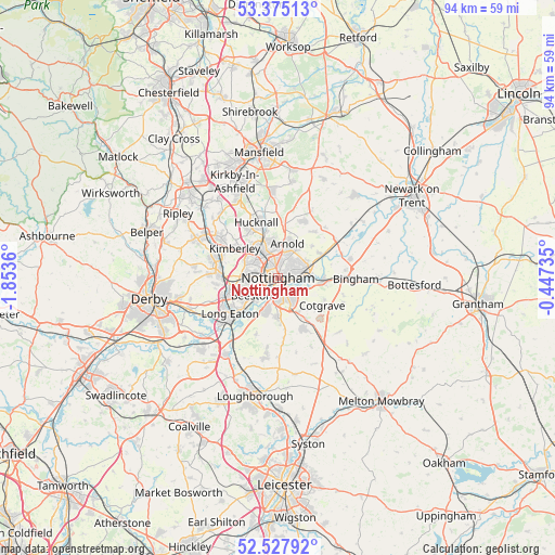
Nottingham GPS coordinates[2]
52° 57' 12.96" North, 1° 9' 1.692" West
| Map corner | latitude | longitude |
|---|---|---|
| Upper-left | 53.37513°, | -1.8536° |
| Center: | 52.9536°, | -1.15047° |
| Lower-right: | 52.52792°, | -0.44735° |
| Map W x H: | 94.2×94.2 km | = 58.5×58.5mi |
| max Lat: | 60.39635° ⇑40.1% North |
| Nottingham: | 52.9536° |
| min Lat: | ⇓59.9% South 34.60088° |
| min Long | Nottingham | max Long |
| -7.64133° | -1.15047° | 32.95536° |
| W 63.7%⇐ | ⇒36.3% E |
Elevation
Elevation of Nottingham is 46 m = 151 ft, and this is 26.9 m = 88 ft below average elevation for this country.
| Max E: |
515 m = 1690 ft | 60.2% |
| Avg. | 72.9 m = 239 ft | |
| Nottingham | 46 m = 151 ft | |
Min E: |
-30 m = -98 ft | 39.8% |
See also: Nottingham elevation on elevation.city.
Geographical zone
Nottingham is located in North temperate zone (between Tropic of Cancer and the Arctic Circle). Distance of this North polar circle is 1513.3 km =940.3 mi to North.| Distance of | km | miles | from Nottingham |
|---|---|---|---|
| North Pole | 4119.2 | 2559.6 | to North |
| Arctic Circle | 1513.3 | 940.3 | to North |
| Tropic Cancer | 3282 | 2039.3 | to South |
| Equator | 5887.9 | 3658.6 | to South |


Nearby cities:
15 places around Nottingham: (largest is in red/bold)
• Arnold
5.3 km =3.3 mi,  12°
12°
• Awsworth
9.7 km =6 mi,  293°
293°
• Basford
2.6 km =1.6 mi,  303°
303°
• Burton Joyce
8.7 km =5.4 mi,  63°
63°
• Cotgrave
9.1 km =5.7 mi,  123°
123°
• Gotham
10.2 km =6.3 mi,  201°
201°
• Hucknall
9.5 km =5.9 mi,  339°
339°
• Keyworth
10 km =6.2 mi,  156°
156°
• Kimberley
8.5 km =5.3 mi, 293°
• Lambley
7.9 km =4.9 mi,  47°
47°
• Long Eaton
10.2 km =6.3 mi,  232°
232°
• New Basford
2.4 km =1.5 mi, 335°
• Radcliffe on Trent
7.5 km =4.7 mi,  94°
94°
• Ruddington
6.8 km =4.2 mi,  179°
179°
• West Bridgford
3.1 km =1.9 mi,  147°
147°
Sources, notices
• [Note1] Compared only with cities in United Kingdom existing in our database
• [Src1] Map data: © OpenStreetMap contributors (CC-BY-SA)
• [Src2] Other city data from geonames.org with taken over terms of usage.
• [Src3] Geographical zone / Annual Mean Temperature by Robert A. Rohde @ Wikipedia
