Norwich geodata
Norwich (England) is a seat of a second-order administrative division; located in United Kingdom in Europe/London (GMT+1) time zone. With population of 213,166 people, there are 37 cities with bigger population in this country. Compared to other cities in United Kingdom, 53.1% of cities are located further ↓South; 98.4% of cities are located further ←West and 82% of cities have higher elevation than Norwich. Note1


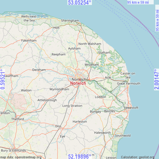
Norwich GPS coordinates[2]
52° 37' 40.188" North, 1° 17' 54.024" East
| Map corner | latitude | longitude |
|---|---|---|
| Upper-left | 53.05254°, | 0.59521° |
| Center: | 52.62783°, | 1.29834° |
| Lower-right: | 52.19896°, | 2.00147° |
| Map W x H: | 94.9×94.9 km | = 59×59mi |
| max Lat: | 60.39635° ⇑46.9% North |
| Norwich: | 52.62783° |
| min Lat: | ⇓53.1% South 34.60088° |
| min Long | Norwich | max Long |
| -7.64133° | 1.29834° | 32.95536° |
| W 98.4%⇐ | ⇒1.6% E |
Elevation
Elevation of Norwich is 19 m = 62 ft, and this is 53.9 m = 177 ft below average elevation for this country.
| Max E: |
515 m = 1690 ft | 82% |
| Avg. | 72.9 m = 239 ft | |
| Norwich | 19 m = 62 ft | |
Min E: |
-30 m = -98 ft | 18% |
See also: Norwich elevation on elevation.city.
Geographical zone
Norwich is located in North temperate zone (between Tropic of Cancer and the Arctic Circle). Distance of this North polar circle is 1549.5 km =962.8 mi to North.| Distance of | km | miles | from Norwich |
|---|---|---|---|
| North Pole | 4155.4 | 2582 | to North |
| Arctic Circle | 1549.5 | 962.8 | to North |
| Tropic Cancer | 3245.7 | 2016.8 | to South |
| Equator | 5851.7 | 3636.1 | to South |


Nearby cities:
15 places around Norwich: (largest is in red/bold)
• Alpington
8.8 km =5.5 mi,  139°
139°
• Bowthorpe
5.5 km =3.4 mi,  282°
282°
• Costessey
6.9 km =4.3 mi,  300°
300°
• Cringleford
4.5 km =2.8 mi,  235°
235°
• Little Plumstead
8.8 km =5.5 mi,  67°
67°
• Mulbarton
8.8 km =5.5 mi,  209°
209°
• Poringland
7.5 km =4.7 mi,  152°
152°
• Rackheath
6.7 km =4.2 mi,  55°
55°
• Rockland Saint Mary
8.7 km =5.4 mi,  121°
121°
• Spixworth
6.6 km =4.1 mi,  13°
13°
• Sprowston
3.4 km =2.1 mi,  43°
43°
• Stoke Holy Cross
6.4 km =4 mi,  182°
182°
• Surlingham
8.5 km =5.3 mi,  105°
105°
• Swardeston
6.7 km =4.2 mi, 210°
• Thorpe Hamlet
0.9 km =0.6 mi,  90°
90°
Sources, notices
• [Note1] Compared only with cities in United Kingdom existing in our database
• [Src1] Map data: © OpenStreetMap contributors (CC-BY-SA)
• [Src2] Other city data from geonames.org with taken over terms of usage.
• [Src3] Geographical zone / Annual Mean Temperature by Robert A. Rohde @ Wikipedia
