Northwich geodata
Northwich (England) is a populated place; located in United Kingdom in Europe/London (GMT+1) time zone. With population of 47,421 people, there are 248 cities with bigger population in this country. Compared to other cities in United Kingdom, 65% of cities are located further ↓South; 65.5% of cities are located further →East and 67.5% of cities have higher elevation than Northwich. Note1


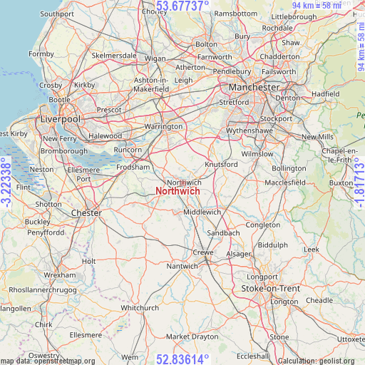
Northwich GPS coordinates[2]
53° 15' 31.752" North, 2° 31' 12.9" West
| Map corner | latitude | longitude |
|---|---|---|
| Upper-left | 53.67737°, | -3.22338° |
| Center: | 53.25882°, | -2.52025° |
| Lower-right: | 52.83614°, | -1.81713° |
| Map W x H: | 93.5×93.5 km | = 58.1×58.1mi |
| max Lat: | 60.39635° ⇑35% North |
| Northwich: | 53.25882° |
| min Lat: | ⇓65% South 34.60088° |
| min Long | Northwich | max Long |
| -7.64133° | -2.52025° | 32.95536° |
| W 34.5%⇐ | ⇒65.5% E |
Elevation
Elevation of Northwich is 36 m = 118 ft, and this is 36.9 m = 121 ft below average elevation for this country.
| Max E: |
515 m = 1690 ft | 67.5% |
| Avg. | 72.9 m = 239 ft | |
| Northwich | 36 m = 118 ft | |
Min E: |
-30 m = -98 ft | 32.5% |
See also: Northwich elevation on elevation.city.
Geographical zone
Northwich is located in North temperate zone (between Tropic of Cancer and the Arctic Circle). Distance of this North polar circle is 1479.3 km =919.2 mi to North.| Distance of | km | miles | from Northwich |
|---|---|---|---|
| North Pole | 4085.2 | 2538.4 | to North |
| Arctic Circle | 1479.3 | 919.2 | to North |
| Tropic Cancer | 3315.9 | 2060.4 | to South |
| Equator | 5921.8 | 3679.6 | to South |


Nearby cities:
15 places around Northwich: (largest is in red/bold)
• Appleton
11 km =6.8 mi,  341°
341°
• Appleton Thorn
10.3 km =6.4 mi,  350°
350°
• Cuddington
6.7 km =4.2 mi,  256°
256°
• Hartford
2.6 km =1.6 mi,  233°
233°
• High Legh
11.2 km =7 mi,  23°
23°
• Kingsley
9.8 km =6.1 mi,  275°
275°
• Knutsford
10.8 km =6.7 mi,  63°
63°
• Marston
1.6 km =1 mi, 57°
• Mere
11 km =6.8 mi,  42°
42°
• Middlewich
8.9 km =5.5 mi,  145°
145°
• Oakmere
9.1 km =5.7 mi,  241°
241°
• Over
8.6 km =5.3 mi,  193°
193°
• Stretton
8.8 km =5.5 mi, 339°
• Weaverham
3.5 km =2.2 mi,  272°
272°
• Winsford
7.5 km =4.7 mi,  181°
181°
Sources, notices
• [Note1] Compared only with cities in United Kingdom existing in our database
• [Src1] Map data: © OpenStreetMap contributors (CC-BY-SA)
• [Src2] Other city data from geonames.org with taken over terms of usage.
• [Src3] Geographical zone / Annual Mean Temperature by Robert A. Rohde @ Wikipedia
