Newport geodata
Newport (Wales) is a seat of a second-order administrative division; located in United Kingdom in Europe/London (GMT+1) time zone. With population of 306,844 people, there are 21 cities with bigger population in this country. Compared to other cities in United Kingdom, 74.8% of cities are located further ↑North; 75.2% of cities are located further →East and 84.7% of cities have higher elevation than Newport. Note1


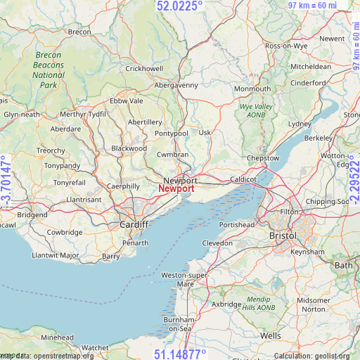
Newport GPS coordinates[2]
51° 35' 15.864" North, 2° 59' 54.06" West
| Map corner | latitude | longitude |
|---|---|---|
| Upper-left | 52.0225°, | -3.70147° |
| Center: | 51.58774°, | -2.99835° |
| Lower-right: | 51.14877°, | -2.29522° |
| Map W x H: | 97.1×97.1 km | = 60.3×60.3mi |
| max Lat: | 60.39635° ⇑74.8% North |
| Newport: | 51.58774° |
| min Lat: | ⇓25.2% South 34.60088° |
| min Long | Newport | max Long |
| -7.64133° | -2.99835° | 32.95536° |
| W 24.8%⇐ | ⇒75.2% E |
Elevation
Elevation of Newport is 16 m = 52 ft, and this is 56.9 m = 187 ft below average elevation for this country.
| Max E: |
515 m = 1690 ft | 84.7% |
| Avg. | 72.9 m = 239 ft | |
| Newport | 16 m = 52 ft | |
Min E: |
-30 m = -98 ft | 15.3% |
See also: Newport elevation on elevation.city.
Geographical zone
Newport is located in North temperate zone (between Tropic of Cancer and the Arctic Circle). Distance of this North polar circle is 1665.2 km =1034.7 mi to North.| Distance of | km | miles | from Newport |
|---|---|---|---|
| North Pole | 4271 | 2653.9 | to North |
| Arctic Circle | 1665.2 | 1034.7 | to North |
| Tropic Cancer | 3130.1 | 1945 | to South |
| Equator | 5736 | 3564.2 | to South |


Nearby cities:
15 places around Newport: (largest is in red/bold)
• Bishton
8.3 km =5.2 mi,  94°
94°
• Caerleon
3.9 km =2.4 mi,  51°
51°
• Crosskeys
9.3 km =5.8 mi,  291°
291°
• Cwmbran
7.6 km =4.7 mi,  347°
347°
• Goldcliff
7.5 km =4.7 mi,  132°
132°
• Langstone
6.3 km =3.9 mi,  71°
71°
• Llangybi
10.7 km =6.6 mi,  35°
35°
• Llanwern
5.9 km =3.7 mi, 88°
• Machen
10 km =6.2 mi,  275°
275°
• Marshfield
7.9 km =4.9 mi,  220°
220°
• Nash
5.6 km =3.5 mi,  140°
140°
• Parc Seymour
10.4 km =6.5 mi, 68°
• Ponthir
5.2 km =3.2 mi,  17°
17°
• Redwick
11 km =6.8 mi,  110°
110°
• Risca
7.4 km =4.6 mi, 287°
Sources, notices
• [Note1] Compared only with cities in United Kingdom existing in our database
• [Src1] Map data: © OpenStreetMap contributors (CC-BY-SA)
• [Src2] Other city data from geonames.org with taken over terms of usage.
• [Src3] Geographical zone / Annual Mean Temperature by Robert A. Rohde @ Wikipedia
