Newbiggin-by-the-Sea geodata
Newbiggin-by-the-Sea (England) is a populated place; located in United Kingdom in Europe/London (GMT+0) time zone. With population of 6,308 people, there are 1421 cities with bigger population in this country. Compared to other cities in United Kingdom, 87.7% of cities are located further ↓South; 55.2% of cities are located further ←West and 91.2% of cities have higher elevation than Newbiggin-by-the-Sea. Note1


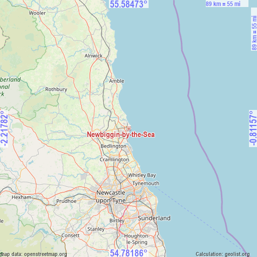
Newbiggin-by-the-Sea GPS coordinates[2]
55° 11' 7.152" North, 1° 30' 52.884" West
| Map corner | latitude | longitude |
|---|---|---|
| Upper-left | 55.58473°, | -2.21782° |
| Center: | 55.18532°, | -1.51469° |
| Lower-right: | 54.78186°, | -0.81157° |
| Map W x H: | 89.3×89.3 km | = 55.5×55.5mi |
| max Lat: | 60.39635° ⇑12.3% North |
| Newbiggin-by-the-Sea: | 55.18532° |
| min Lat: | ⇓87.7% South 34.60088° |
| min Long | Newbiggin-by-th | max Long |
| -7.64133° | -1.51469° | 32.95536° |
| W 55.2%⇐ | ⇒44.8% E |
Elevation
Elevation of Newbiggin-by-the-Sea is 11 m = 36 ft, and this is 61.9 m = 203 ft below average elevation for this country.
| Max E: |
515 m = 1690 ft | 91.2% |
| Avg. | 72.9 m = 239 ft | |
| Newbiggin-by-the-Sea | 11 m = 36 ft | |
Min E: |
-30 m = -98 ft | 8.8% |
See also: United Kingdom elevation on elevation.city.
Geographical zone
Newbiggin-by-the-Sea is located in North temperate zone (between Tropic of Cancer and the Arctic Circle). Distance of this North polar circle is 1265.1 km =786.1 mi to North.| Distance of | km | miles | from Newbiggin-by-the-Sea |
|---|---|---|---|
| North Pole | 3871 | 2405.3 | to North |
| Arctic Circle | 1265.1 | 786.1 | to North |
| Tropic Cancer | 3530.1 | 2193.5 | to South |
| Equator | 6136 | 3812.7 | to South |


Nearby cities:
15 places around Newbiggin-by-the-Sea: (largest is in red/bold)
• Ashington
3.3 km =2.1 mi,  253°
253°
• Bedlington
7.9 km =4.9 mi,  219°
219°
• Blyth
6.5 km =4 mi,  176°
176°
• Choppington
6.9 km =4.3 mi,  235°
235°
• Cramlington
11.9 km =7.4 mi,  202°
202°
• Cresswell
4.1 km =2.5 mi,  327°
327°
• East Chevington
11.7 km =7.3 mi,  338°
338°
• Hadston
13.4 km =8.3 mi, 334°
• Hebron
10.7 km =6.6 mi,  268°
268°
• Lynemouth
3.6 km =2.2 mi, 330°
• Morpeth
11.2 km =7 mi,  260°
260°
• Pegswood
8.3 km =5.2 mi, 265°
• Seaton Delaval
12.6 km =7.8 mi, 183°
• Stakeford
4.7 km =2.9 mi, 235°
• Stannington
13 km =8.1 mi,  228°
228°
Sources, notices
• [Note1] Compared only with cities in United Kingdom existing in our database
• [Src1] Map data: © OpenStreetMap contributors (CC-BY-SA)
• [Src2] Other city data from geonames.org with taken over terms of usage.
• [Src3] Geographical zone / Annual Mean Temperature by Robert A. Rohde @ Wikipedia
