Neston geodata
Neston (England) is a seat of a third-order administrative division; located in United Kingdom in Europe/London (GMT+1) time zone. With population of 15,064 people, there are 766 cities with bigger population in this country. Compared to other cities in United Kingdom, 65.5% of cities are located further ↓South; 76.3% of cities are located further →East and 58.5% of cities have higher elevation than Neston. Note1


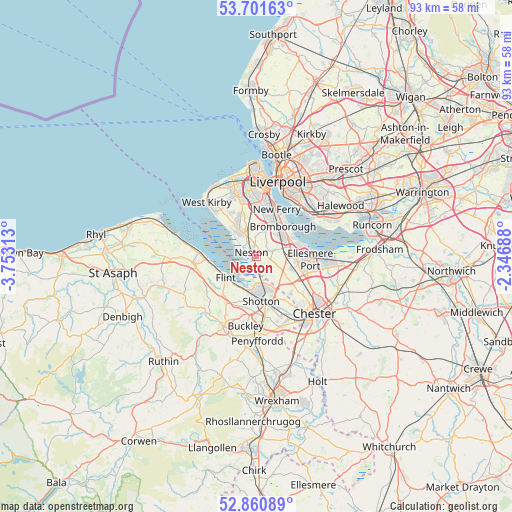
Neston GPS coordinates[2]
53° 16' 59.988" North, 3° 3' 0" West
| Map corner | latitude | longitude |
|---|---|---|
| Upper-left | 53.70163°, | -3.75313° |
| Center: | 53.28333°, | -3.05° |
| Lower-right: | 52.86089°, | -2.34688° |
| Map W x H: | 93.5×93.5 km | = 58.1×58.1mi |
| max Lat: | 60.39635° ⇑34.5% North |
| Neston: | 53.28333° |
| min Lat: | ⇓65.5% South 34.60088° |
| min Long | Neston | max Long |
| -7.64133° | -3.05° | 32.95536° |
| W 23.7%⇐ | ⇒76.3% E |
Elevation
Elevation of Neston is 49 m = 161 ft, and this is 23.9 m = 78 ft below average elevation for this country.
| Max E: |
515 m = 1690 ft | 58.5% |
| Avg. | 72.9 m = 239 ft | |
| Neston | 49 m = 161 ft | |
Min E: |
-30 m = -98 ft | 41.5% |
See also: United Kingdom elevation on elevation.city.
Geographical zone
Neston is located in North temperate zone (between Tropic of Cancer and the Arctic Circle). Distance of this North polar circle is 1476.6 km =917.5 mi to North.| Distance of | km | miles | from Neston |
|---|---|---|---|
| North Pole | 4082.5 | 2536.7 | to North |
| Arctic Circle | 1476.6 | 917.5 | to North |
| Tropic Cancer | 3318.6 | 2062.1 | to South |
| Equator | 5924.6 | 3681.4 | to South |


Nearby cities:
15 places around Neston: (largest is in red/bold)
• Bagillt
7.9 km =4.9 mi,  255°
255°
• Bebington
7.7 km =4.8 mi,  16°
16°
• Bromborough
8.6 km =5.3 mi,  32°
32°
• Burton
3.1 km =1.9 mi,  148°
148°
• Childer Thornton
5.2 km =3.2 mi,  77°
77°
• Deeside
9.2 km =5.7 mi,  175°
175°
• Flint
6.9 km =4.3 mi,  232°
232°
• Heswall
5.8 km =3.6 mi,  327°
327°
• Ledsham
5.8 km =3.6 mi,  108°
108°
• New Ferry
9.4 km =5.8 mi, 23°
• Prenton
9.4 km =5.8 mi,  358°
358°
• Queensferry
9.3 km =5.8 mi,  173°
173°
• Saughall
8.9 km =5.5 mi,  135°
135°
• Shotwick
6.3 km =3.9 mi, 141°
• Willaston
3.8 km =2.4 mi,  68°
68°
Sources, notices
• [Note1] Compared only with cities in United Kingdom existing in our database
• [Src1] Map data: © OpenStreetMap contributors (CC-BY-SA)
• [Src2] Other city data from geonames.org with taken over terms of usage.
• [Src3] Geographical zone / Annual Mean Temperature by Robert A. Rohde @ Wikipedia
