Middleton on the Wolds geodata
Middleton on the Wolds (England) is a populated place; located in United Kingdom in Europe/London (GMT+1) time zone. With population of 825 people, there are 3986 cities with bigger population in this country. Compared to other cities in United Kingdom, 77.9% of cities are located further ↓South; 75.3% of cities are located further ←West and 63.1% of cities have higher elevation than Middleton on the Wolds. Note1


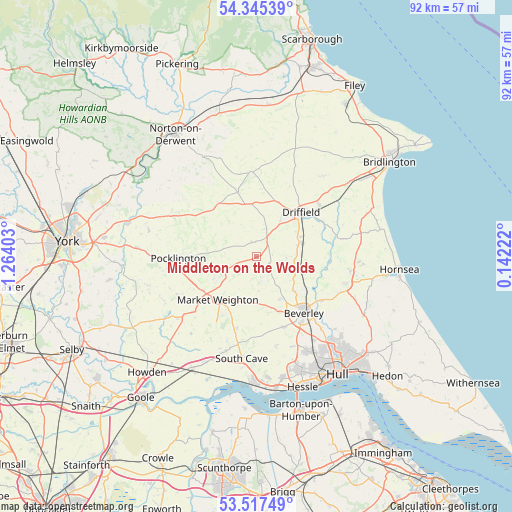
Middleton on the Wolds GPS coordinates[2]
53° 56' 0.564" North, 0° 33' 39.24" West
| Map corner | latitude | longitude |
|---|---|---|
| Upper-left | 54.34539°, | -1.26403° |
| Center: | 53.93349°, | -0.5609° |
| Lower-right: | 53.51749°, | 0.14222° |
| Map W x H: | 92.1×92.1 km | = 57.2×57.2mi |
| max Lat: | 60.39635° ⇑22.1% North |
| Middleton on the Wolds: | 53.93349° |
| min Lat: | ⇓77.9% South 34.60088° |
| min Long | Middleton on th | max Long |
| -7.64133° | -0.5609° | 32.95536° |
| W 75.3%⇐ | ⇒24.7% E |
Elevation
Elevation of Middleton on the Wolds is 42 m = 138 ft, and this is 30.9 m = 101 ft below average elevation for this country.
| Max E: |
515 m = 1690 ft | 63.1% |
| Avg. | 72.9 m = 239 ft | |
| Middleton on the Wolds | 42 m = 138 ft | |
Min E: |
-30 m = -98 ft | 36.9% |
See also: United Kingdom elevation on elevation.city.
Geographical zone
Middleton on the Wolds is located in North temperate zone (between Tropic of Cancer and the Arctic Circle). Distance of this North polar circle is 1404.3 km =872.6 mi to North.| Distance of | km | miles | from Middleton on the Wolds |
|---|---|---|---|
| North Pole | 4010.2 | 2491.8 | to North |
| Arctic Circle | 1404.3 | 872.6 | to North |
| Tropic Cancer | 3390.9 | 2107 | to South |
| Equator | 5996.8 | 3726.2 | to South |


Nearby cities:
15 places around Middleton on the Wolds: (largest is in red/bold)
• Bainton
2.6 km =1.6 mi,  44°
44°
• Bishop Burton
10.6 km =6.6 mi,  157°
157°
• Cherry Burton
8.4 km =5.2 mi,  151°
151°
• Driffield
11.1 km =6.9 mi, 43°
• Etton
6.9 km =4.3 mi, 152°
• Hutton
9.1 km =5.7 mi,  66°
66°
• Leconfield
9.2 km =5.7 mi,  132°
132°
• Lockington
5.4 km =3.4 mi,  113°
113°
• Londesborough
9.8 km =6.1 mi,  235°
235°
• Lund
3 km =1.9 mi,  122°
122°
• Market Weighton
10.4 km =6.5 mi,  221°
221°
• Millington
11.4 km =7.1 mi,  279°
279°
• Shiptonthorpe
11.3 km =7 mi, 237°
• Watton
7.3 km =4.5 mi,  90°
90°
• Wetwang
9.4 km =5.8 mi,  353°
353°
Sources, notices
• [Note1] Compared only with cities in United Kingdom existing in our database
• [Src1] Map data: © OpenStreetMap contributors (CC-BY-SA)
• [Src2] Other city data from geonames.org with taken over terms of usage.
• [Src3] Geographical zone / Annual Mean Temperature by Robert A. Rohde @ Wikipedia
