Marsh Gibbon geodata
Marsh Gibbon (England) is a populated place; located in United Kingdom in Europe/London (GMT+1) time zone. With population of 969 people, there are 3698 cities with bigger population in this country. Compared to other cities in United Kingdom, 64.8% of cities are located further ↑North; 65.5% of cities are located further ←West and 55.8% of cities have lower elevation than Marsh Gibbon. Note1
Administrative division(s):
- Level 1: England
- Level 2: Buckinghamshire
- Level 3: Aylesbury Vale
- Level 4: Marsh Gibbon


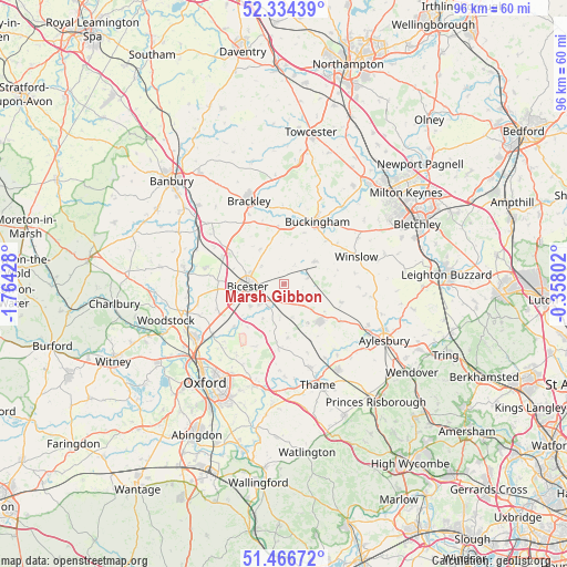
Marsh Gibbon GPS coordinates[2]
51° 54' 9.54" North, 1° 3' 40.14" West
| Map corner | latitude | longitude |
|---|---|---|
| Upper-left | 52.33439°, | -1.76428° |
| Center: | 51.90265°, | -1.06115° |
| Lower-right: | 51.46672°, | -0.35802° |
| Map W x H: | 96.5×96.5 km | = 60×60mi |
| max Lat: | 60.39635° ⇑64.8% North |
| Marsh Gibbon: | 51.90265° |
| min Lat: | ⇓35.2% South 34.60088° |
| min Long | Marsh Gibbon | max Long |
| -7.64133° | -1.06115° | 32.95536° |
| W 65.5%⇐ | ⇒34.5% E |
Elevation
Elevation of Marsh Gibbon is 70 m = 230 ft, and this is 2.9 m = 10 ft below average elevation for this country.
| Max E: |
515 m = 1690 ft | 44.2% |
| Avg. | 72.9 m = 239 ft | |
| Marsh Gibbon | 70 m = 230 ft | |
Min E: |
-30 m = -98 ft | 55.8% |
See also: United Kingdom elevation on elevation.city.
Geographical zone
Marsh Gibbon is located in North temperate zone (between Tropic of Cancer and the Arctic Circle). Distance of this North polar circle is 1630.1 km =1012.9 mi to North.| Distance of | km | miles | from Marsh Gibbon |
|---|---|---|---|
| North Pole | 4236 | 2632.1 | to North |
| Arctic Circle | 1630.1 | 1012.9 | to North |
| Tropic Cancer | 3165.1 | 1966.7 | to South |
| Equator | 5771 | 3585.9 | to South |


Nearby cities:
15 places around Marsh Gibbon: (largest is in red/bold)
• Ambrosden
5.4 km =3.4 mi,  229°
229°
• Bicester
6.3 km =3.9 mi,  267°
267°
• Brill
9.6 km =6 mi,  175°
175°
• Buckingham
11.9 km =7.4 mi,  24°
24°
• Chesterton
8.7 km =5.4 mi,  258°
258°
• Edgcott
3.7 km =2.3 mi,  108°
108°
• Fringford
7.1 km =4.4 mi,  323°
323°
• Gawcott
9.4 km =5.8 mi, 21°
• Grendon Underwood
3.7 km =2.3 mi,  125°
125°
• Oakley
11 km =6.8 mi, 184°
• Padbury
10.6 km =6.6 mi,  44°
44°
• Quainton
10.4 km =6.5 mi, 107°
• Steeple Claydon
6.5 km =4 mi,  54°
54°
• Tingewick
9.8 km =6.1 mi,  5°
5°
• Waddesdon
11.5 km =7.1 mi,  122°
122°
Sources, notices
• [Note1] Compared only with cities in United Kingdom existing in our database
• [Src1] Map data: © OpenStreetMap contributors (CC-BY-SA)
• [Src2] Other city data from geonames.org with taken over terms of usage.
• [Src3] Geographical zone / Annual Mean Temperature by Robert A. Rohde @ Wikipedia
