Market Drayton geodata
Market Drayton (England) is a seat of a third-order administrative division; located in United Kingdom in Europe/London (GMT+1) time zone. With population of 11,773 people, there are 928 cities with bigger population in this country. Compared to other cities in United Kingdom, 59.1% of cities are located further ↓South; 64.9% of cities are located further →East and 74.6% of cities have lower elevation than Market Drayton. Note1


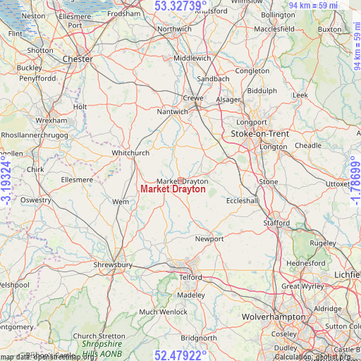
Market Drayton GPS coordinates[2]
52° 54' 19.368" North, 2° 29' 24.432" West
| Map corner | latitude | longitude |
|---|---|---|
| Upper-left | 53.32739°, | -3.19324° |
| Center: | 52.90538°, | -2.49012° |
| Lower-right: | 52.47922°, | -1.78699° |
| Map W x H: | 94.3×94.3 km | = 58.6×58.6mi |
| max Lat: | 60.39635° ⇑40.9% North |
| Market Drayton: | 52.90538° |
| min Lat: | ⇓59.1% South 34.60088° |
| min Long | Market Drayton | max Long |
| -7.64133° | -2.49012° | 32.95536° |
| W 35.1%⇐ | ⇒64.9% E |
Elevation
Elevation of Market Drayton is 105 m = 344 ft, and this is 32.1 m = 105 ft above average elevation for this country.
| Max E: |
515 m = 1690 ft | 25.4% |
| Market Drayton | 105 m 344 ft | |
| Avg. | 72.9 m = 239 ft | |
Min E: |
-30 m = -98 ft | 74.6% |
See also: United Kingdom elevation on elevation.city.
Geographical zone
Market Drayton is located in North temperate zone (between Tropic of Cancer and the Arctic Circle). Distance of this North polar circle is 1518.6 km =943.6 mi to North.| Distance of | km | miles | from Market Drayton |
|---|---|---|---|
| North Pole | 4124.5 | 2562.8 | to North |
| Arctic Circle | 1518.6 | 943.6 | to North |
| Tropic Cancer | 3276.6 | 2036 | to South |
| Equator | 5882.5 | 3655.2 | to South |


Nearby cities:
15 places around Market Drayton: (largest is in red/bold)
• Ash
11.8 km =7.3 mi,  294°
294°
• Audlem
9.4 km =5.8 mi,  353°
353°
• Cheswardine
6.6 km =4.1 mi,  132°
132°
• Chetwynd
14.9 km =9.3 mi,  155°
155°
• Edgmond
15.6 km =9.7 mi, 159°
• Hinstock
7.9 km =4.9 mi, 163°
• Madeley
14.9 km =9.3 mi,  44°
44°
• Prees
11.7 km =7.3 mi,  265°
265°
• Standon
13.9 km =8.6 mi,  84°
84°
• Stoke upon Tern
6.8 km =4.2 mi,  205°
205°
• Tibberton
14.2 km =8.8 mi,  175°
175°
• Tilstock
13.4 km =8.3 mi,  284°
284°
• Whitchurch
14.6 km =9.1 mi,  297°
297°
• Woore
9.9 km =6.2 mi, 36°
• Wybunbury
15.8 km =9.8 mi,  9°
9°
Sources, notices
• [Note1] Compared only with cities in United Kingdom existing in our database
• [Src1] Map data: © OpenStreetMap contributors (CC-BY-SA)
• [Src2] Other city data from geonames.org with taken over terms of usage.
• [Src3] Geographical zone / Annual Mean Temperature by Robert A. Rohde @ Wikipedia
