Manningtree geodata
Manningtree (England) is a populated place; located in United Kingdom in Europe/London (GMT+1) time zone. With population of 5,696 people, there are 1511 cities with bigger population in this country. Compared to other cities in United Kingdom, 63.8% of cities are located further ↑North; 96.8% of cities are located further ←West and 94.9% of cities have higher elevation than Manningtree. Note1
Administrative division(s):
- Level 1: England
- Level 2: Essex
- Level 3: Tendring District
- Level 4: Manningtree


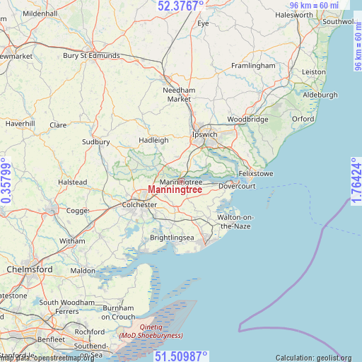
Manningtree GPS coordinates[2]
51° 56' 43.368" North, 1° 3' 40.032" East
| Map corner | latitude | longitude |
|---|---|---|
| Upper-left | 52.3767°, | 0.35799° |
| Center: | 51.94538°, | 1.06112° |
| Lower-right: | 51.50987°, | 1.76424° |
| Map W x H: | 96.4×96.4 km | = 59.9×59.9mi |
| max Lat: | 60.39635° ⇑63.8% North |
| Manningtree: | 51.94538° |
| min Lat: | ⇓36.2% South 34.60088° |
| min Long | Manningtree | max Long |
| -7.64133° | 1.06112° | 32.95536° |
| W 96.8%⇐ | ⇒3.2% E |
Elevation
Elevation of Manningtree is 8 m = 26 ft, and this is 64.9 m = 213 ft below average elevation for this country.
| Max E: |
515 m = 1690 ft | 94.9% |
| Avg. | 72.9 m = 239 ft | |
| Manningtree | 8 m = 26 ft | |
Min E: |
-30 m = -98 ft | 5.1% |
See also: United Kingdom elevation on elevation.city.
Geographical zone
Manningtree is located in North temperate zone (between Tropic of Cancer and the Arctic Circle). Distance of this North polar circle is 1625.4 km =1010 mi to North.| Distance of | km | miles | from Manningtree |
|---|---|---|---|
| North Pole | 4231.3 | 2629.2 | to North |
| Arctic Circle | 1625.4 | 1010 | to North |
| Tropic Cancer | 3169.9 | 1969.7 | to South |
| Equator | 5775.8 | 3588.9 | to South |


Nearby cities:
15 places around Manningtree: (largest is in red/bold)
• Alresford
11 km =6.8 mi,  201°
201°
• Ardleigh
5.6 km =3.5 mi,  247°
247°
• Boxted
10.4 km =6.5 mi,  272°
272°
• Capel Saint Mary
6.6 km =4.1 mi,  350°
350°
• Chelmondiston
11.4 km =7.1 mi,  64°
64°
• Dedham
4.9 km =3 mi,  287°
287°
• East Bergholt
4.7 km =2.9 mi,  320°
320°
• Elmstead Market
8.4 km =5.2 mi,  212°
212°
• Great Bentley
10.2 km =6.3 mi,  178°
178°
• Great Oakley
9.9 km =6.2 mi,  118°
118°
• Holbrook
7.9 km =4.9 mi, 57°
• Mistley
1.5 km =0.9 mi,  98°
98°
• Stutton
5.6 km =3.5 mi, 60°
• Thorpe le Soken
12.3 km =7.6 mi,  144°
144°
• Wivenhoe
12.2 km =7.6 mi,  215°
215°
Sources, notices
• [Note1] Compared only with cities in United Kingdom existing in our database
• [Src1] Map data: © OpenStreetMap contributors (CC-BY-SA)
• [Src2] Other city data from geonames.org with taken over terms of usage.
• [Src3] Geographical zone / Annual Mean Temperature by Robert A. Rohde @ Wikipedia
