Malpas geodata
Malpas (England) is a seat of a third-order administrative division; located in United Kingdom in Europe/London (GMT+1) time zone. With population of 1,321 people, there are 3226 cities with bigger population in this country. Compared to other cities in United Kingdom, 60.8% of cities are located further ↓South; 70.2% of cities are located further →East and 72.2% of cities have lower elevation than Malpas. Note1


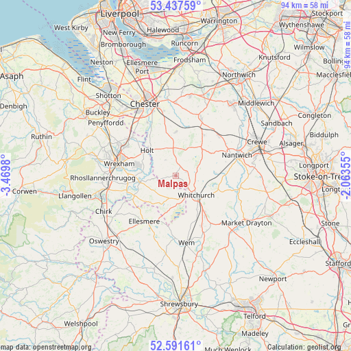
Malpas GPS coordinates[2]
53° 1' 0.012" North, 2° 46' 0.012" West
| Map corner | latitude | longitude |
|---|---|---|
| Upper-left | 53.43759°, | -3.4698° |
| Center: | 53.01667°, | -2.76667° |
| Lower-right: | 52.59161°, | -2.06355° |
| Map W x H: | 94.1×94.1 km | = 58.5×58.5mi |
| max Lat: | 60.39635° ⇑39.2% North |
| Malpas: | 53.01667° |
| min Lat: | ⇓60.8% South 34.60088° |
| min Long | Malpas | max Long |
| -7.64133° | -2.76667° | 32.95536° |
| W 29.8%⇐ | ⇒70.2% E |
Elevation
Elevation of Malpas is 100 m = 328 ft, and this is 27.1 m = 89 ft above average elevation for this country.
| Max E: |
515 m = 1690 ft | 27.8% |
| Malpas | 100 m 328 ft | |
| Avg. | 72.9 m = 239 ft | |
Min E: |
-30 m = -98 ft | 72.2% |
See also: United Kingdom elevation on elevation.city.
Geographical zone
Malpas is located in North temperate zone (between Tropic of Cancer and the Arctic Circle). Distance of this North polar circle is 1506.3 km =936 mi to North.| Distance of | km | miles | from Malpas |
|---|---|---|---|
| North Pole | 4112.2 | 2555.2 | to North |
| Arctic Circle | 1506.3 | 936 | to North |
| Tropic Cancer | 3289 | 2043.7 | to South |
| Equator | 5894.9 | 3662.9 | to South |


Nearby cities:
15 places around Malpas: (largest is in red/bold)
• Ash
10.8 km =6.7 mi,  133°
133°
• Beeston
12.4 km =7.7 mi,  26°
26°
• Bickley
4.8 km =3 mi,  67°
67°
• Carden
6.5 km =4 mi,  341°
341°
• Coddington
8.1 km =5 mi, 335°
• Farndon
10.4 km =6.5 mi,  315°
315°
• Harthill
7.5 km =4.7 mi,  8°
8°
• Holt
9.6 km =6 mi,  305°
305°
• Marchwiel
13 km =8.1 mi,  273°
273°
• Overton
12.5 km =7.8 mi,  243°
243°
• Penley
9.9 km =6.2 mi,  224°
224°
• Tattenhall
11.7 km =7.3 mi,  359°
359°
• Tilstock
10.6 km =6.6 mi,  148°
148°
• Tilston
5.3 km =3.3 mi,  327°
327°
• Whitchurch
7.9 km =4.9 mi, 134°
Sources, notices
• [Note1] Compared only with cities in United Kingdom existing in our database
• [Src1] Map data: © OpenStreetMap contributors (CC-BY-SA)
• [Src2] Other city data from geonames.org with taken over terms of usage.
• [Src3] Geographical zone / Annual Mean Temperature by Robert A. Rohde @ Wikipedia
