Maidstone geodata
Maidstone (England) is a seat of a second-order administrative division; located in United Kingdom in Europe/London (GMT+1) time zone. With population of 107,627 people, there are 88 cities with bigger population in this country. Compared to other cities in United Kingdom, 85.1% of cities are located further ↑North; 92.5% of cities are located further ←West and 93.6% of cities have higher elevation than Maidstone. Note1


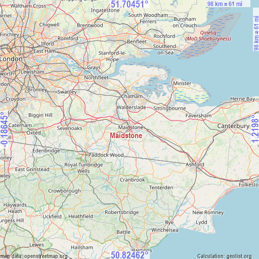
Maidstone GPS coordinates[2]
51° 16' 0.012" North, 0° 31' 0.012" East
| Map corner | latitude | longitude |
|---|---|---|
| Upper-left | 51.70451°, | -0.18645° |
| Center: | 51.26667°, | 0.51667° |
| Lower-right: | 50.82462°, | 1.2198° |
| Map W x H: | 97.8×97.8 km | = 60.8×60.8mi |
| max Lat: | 60.39635° ⇑85.1% North |
| Maidstone: | 51.26667° |
| min Lat: | ⇓14.9% South 34.60088° |
| min Long | Maidstone | max Long |
| -7.64133° | 0.51667° | 32.95536° |
| W 92.5%⇐ | ⇒7.5% E |
Elevation
Elevation of Maidstone is 9 m = 30 ft, and this is 63.9 m = 210 ft below average elevation for this country.
| Max E: |
515 m = 1690 ft | 93.6% |
| Avg. | 72.9 m = 239 ft | |
| Maidstone | 9 m = 30 ft | |
Min E: |
-30 m = -98 ft | 6.4% |
See also: Maidstone elevation on elevation.city.
Geographical zone
Maidstone is located in North temperate zone (between Tropic of Cancer and the Arctic Circle). Distance of this North polar circle is 1700.9 km =1056.9 mi to North.| Distance of | km | miles | from Maidstone |
|---|---|---|---|
| North Pole | 4306.7 | 2676.1 | to North |
| Arctic Circle | 1700.9 | 1056.9 | to North |
| Tropic Cancer | 3094.4 | 1922.8 | to South |
| Equator | 5700.3 | 3542 | to South |


Nearby cities:
15 places around Maidstone: (largest is in red/bold)
• Aylesford
4.9 km =3 mi,  327°
327°
• Boxley
4.4 km =2.7 mi,  24°
24°
• Burham
7.8 km =4.8 mi,  339°
339°
• Detling
4.8 km =3 mi,  50°
50°
• East Peckham
10.9 km =6.8 mi,  236°
236°
• Halling
10.7 km =6.6 mi, 332°
• Kings Hill
8 km =5 mi,  276°
276°
• Larkfield
6.1 km =3.8 mi,  309°
309°
• Marden
10.4 km =6.5 mi,  190°
190°
• Snodland
8.7 km =5.4 mi,  323°
323°
• Ulcombe
10.9 km =6.8 mi,  125°
125°
• Wateringbury
6.6 km =4.1 mi,  259°
259°
• West Malling
8 km =5 mi,  291°
291°
• Wouldham
10.1 km =6.3 mi, 336°
• Yalding
7.7 km =4.8 mi,  231°
231°
Sources, notices
• [Note1] Compared only with cities in United Kingdom existing in our database
• [Src1] Map data: © OpenStreetMap contributors (CC-BY-SA)
• [Src2] Other city data from geonames.org with taken over terms of usage.
• [Src3] Geographical zone / Annual Mean Temperature by Robert A. Rohde @ Wikipedia
