Luckington geodata
Luckington (England) is a seat of a third-order administrative division; located in United Kingdom in Europe/London (GMT+0) time zone. With population of 630 people, there are 4492 cities with bigger population in this country. Compared to other cities in United Kingdom, 75.8% of cities are located further ↑North; 60.1% of cities are located further →East and 82.2% of cities have lower elevation than Luckington. Note1


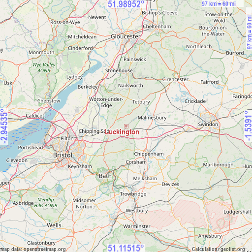
Luckington GPS coordinates[2]
51° 33' 15.984" North, 2° 14' 31.992" West
| Map corner | latitude | longitude |
|---|---|---|
| Upper-left | 51.98952°, | -2.94535° |
| Center: | 51.55444°, | -2.24222° |
| Lower-right: | 51.11515°, | -1.5391° |
| Map W x H: | 97.2×97.2 km | = 60.4×60.4mi |
| max Lat: | 60.39635° ⇑75.8% North |
| Luckington: | 51.55444° |
| min Lat: | ⇓24.2% South 34.60088° |
| min Long | Luckington | max Long |
| -7.64133° | -2.24222° | 32.95536° |
| W 39.9%⇐ | ⇒60.1% E |
Elevation
Elevation of Luckington is 124 m = 407 ft, and this is 51.1 m = 168 ft above average elevation for this country.
| Max E: |
515 m = 1690 ft | 17.8% |
| Luckington | 124 m 407 ft | |
| Avg. | 72.9 m = 239 ft | |
Min E: |
-30 m = -98 ft | 82.2% |
See also: United Kingdom elevation on elevation.city.
Geographical zone
Luckington is located in North temperate zone (between Tropic of Cancer and the Arctic Circle). Distance of this North polar circle is 1668.9 km =1037 mi to North.| Distance of | km | miles | from Luckington |
|---|---|---|---|
| North Pole | 4274.7 | 2656.2 | to North |
| Arctic Circle | 1668.9 | 1037 | to North |
| Tropic Cancer | 3126.4 | 1942.7 | to South |
| Equator | 5732.3 | 3561.9 | to South |


Nearby cities:
15 places around Luckington: (largest is in red/bold)
• Biddestone
10.8 km =6.7 mi,  163°
163°
• Chipping Sodbury
10.6 km =6.6 mi,  260°
260°
• Hawkesbury Upton
6 km =3.7 mi,  298°
298°
• Horton
7.6 km =4.7 mi,  273°
273°
• Hullavington
6.5 km =4 mi,  106°
106°
• Kington Langley
11.3 km =7 mi,  130°
130°
• Malmesbury
10.5 km =6.5 mi,  73°
73°
• Marshfield
11.6 km =7.2 mi,  207°
207°
• Nettleton
6 km =3.7 mi,  193°
193°
• North Wraxall
9.1 km =5.7 mi, 189°
• Norton
5.4 km =3.4 mi,  84°
84°
• Sherston
2.8 km =1.7 mi,  46°
46°
• Tetbury
10.9 km =6.8 mi,  30°
30°
• Wotton-under-Edge
11.2 km =7 mi,  320°
320°
• Yatton Keynell
8.3 km =5.2 mi, 156°
Sources, notices
• [Note1] Compared only with cities in United Kingdom existing in our database
• [Src1] Map data: © OpenStreetMap contributors (CC-BY-SA)
• [Src2] Other city data from geonames.org with taken over terms of usage.
• [Src3] Geographical zone / Annual Mean Temperature by Robert A. Rohde @ Wikipedia
