Loughborough geodata
Loughborough (England) is a populated place; located in United Kingdom in Europe/London (GMT+1) time zone. With population of 59,932 people, there are 186 cities with bigger population in this country. Compared to other cities in United Kingdom, 56.7% of cities are located further ↓South; 62.7% of cities are located further ←West and 58.5% of cities have higher elevation than Loughborough. Note1


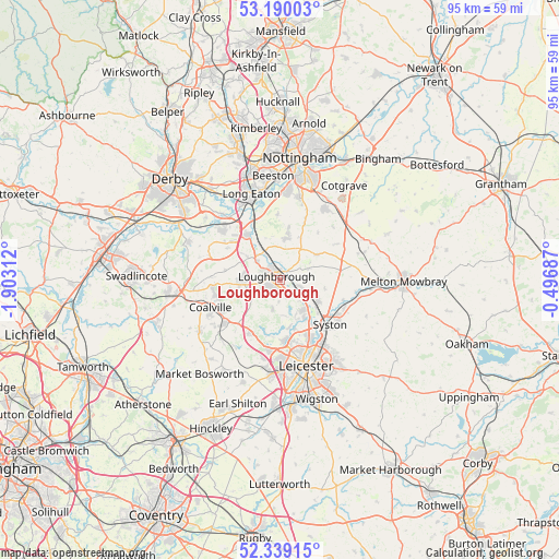
Loughborough GPS coordinates[2]
52° 46' 0.012" North, 1° 12' 0" West
| Map corner | latitude | longitude |
|---|---|---|
| Upper-left | 53.19003°, | -1.90312° |
| Center: | 52.76667°, | -1.2° |
| Lower-right: | 52.33915°, | -0.49687° |
| Map W x H: | 94.6×94.6 km | = 58.8×58.8mi |
| max Lat: | 60.39635° ⇑43.3% North |
| Loughborough: | 52.76667° |
| min Lat: | ⇓56.7% South 34.60088° |
| min Long | Loughborough | max Long |
| -7.64133° | -1.2° | 32.95536° |
| W 62.7%⇐ | ⇒37.3% E |
Elevation
Elevation of Loughborough is 49 m = 161 ft, and this is 23.9 m = 78 ft below average elevation for this country.
| Max E: |
515 m = 1690 ft | 58.5% |
| Avg. | 72.9 m = 239 ft | |
| Loughborough | 49 m = 161 ft | |
Min E: |
-30 m = -98 ft | 41.5% |
See also: Loughborough elevation on elevation.city.
Geographical zone
Loughborough is located in North temperate zone (between Tropic of Cancer and the Arctic Circle). Distance of this North polar circle is 1534.1 km =953.2 mi to North.| Distance of | km | miles | from Loughborough |
|---|---|---|---|
| North Pole | 4140 | 2572.5 | to North |
| Arctic Circle | 1534.1 | 953.2 | to North |
| Tropic Cancer | 3261.2 | 2026.4 | to South |
| Equator | 5867.1 | 3645.6 | to South |


Nearby cities:
15 places around Loughborough: (largest is in red/bold)
• Barrow upon Soar
4 km =2.5 mi,  114°
114°
• Burton on the Wolds
5.2 km =3.2 mi,  65°
65°
• East Leake
7.2 km =4.5 mi,  10°
10°
• Hathern
5 km =3.1 mi,  310°
310°
• Kegworth
9.3 km =5.8 mi,  324°
324°
• Long Whatton
7.2 km =4.5 mi, 307°
• Mountsorrel
6.5 km =4 mi,  148°
148°
• Quorndon
3 km =1.9 mi,  143°
143°
• Rothley
7.7 km =4.8 mi, 146°
• Seagrave
7.9 km =4.9 mi,  102°
102°
• Shepshed
6.1 km =3.8 mi,  268°
268°
• Sileby
7.3 km =4.5 mi,  121°
121°
• Sutton Bonington
6.9 km =4.3 mi,  331°
331°
• Thurcaston
8.7 km =5.4 mi,  161°
161°
• Wymeswold
7.3 km =4.5 mi,  53°
53°
Sources, notices
• [Note1] Compared only with cities in United Kingdom existing in our database
• [Src1] Map data: © OpenStreetMap contributors (CC-BY-SA)
• [Src2] Other city data from geonames.org with taken over terms of usage.
• [Src3] Geographical zone / Annual Mean Temperature by Robert A. Rohde @ Wikipedia
