Lochgilphead geodata
Lochgilphead (Scotland) is a seat of a second-order administrative division; located in United Kingdom in Europe/London (GMT+1) time zone. With population of 2,390 people, there are 2395 cities with bigger population in this country. Compared to other cities in United Kingdom, 94.5% of cities are located further ↓South; 97.4% of cities are located further →East and 94.9% of cities have higher elevation than Lochgilphead. Note1


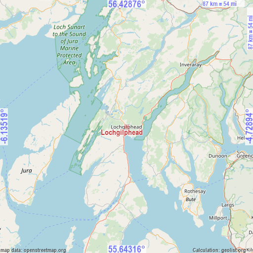
Lochgilphead GPS coordinates[2]
56° 2' 16.656" North, 5° 25' 55.416" West
| Map corner | latitude | longitude |
|---|---|---|
| Upper-left | 56.42876°, | -6.13519° |
| Center: | 56.03796°, | -5.43206° |
| Lower-right: | 55.64316°, | -4.72894° |
| Map W x H: | 87.4×87.3 km | = 54.3×54.2mi |
| max Lat: | 60.39635° ⇑5.5% North |
| Lochgilphead: | 56.03796° |
| min Lat: | ⇓94.5% South 34.60088° |
| min Long | Lochgilphead | max Long |
| -7.64133° | -5.43206° | 32.95536° |
| W 2.6%⇐ | ⇒97.4% E |
Elevation
Elevation of Lochgilphead is 8 m = 26 ft, and this is 64.9 m = 213 ft below average elevation for this country.
| Max E: |
515 m = 1690 ft | 94.9% |
| Avg. | 72.9 m = 239 ft | |
| Lochgilphead | 8 m = 26 ft | |
Min E: |
-30 m = -98 ft | 5.1% |
See also: United Kingdom elevation on elevation.city.
Geographical zone
Lochgilphead is located in North temperate zone (between Tropic of Cancer and the Arctic Circle). Distance of this North polar circle is 1170.3 km =727.2 mi to North.| Distance of | km | miles | from Lochgilphead |
|---|---|---|---|
| North Pole | 3776.2 | 2346.4 | to North |
| Arctic Circle | 1170.3 | 727.2 | to North |
| Tropic Cancer | 3624.9 | 2252.4 | to South |
| Equator | 6230.8 | 3871.6 | to South |


Nearby cities:
15 places around Lochgilphead: (largest is in red/bold)
• Ardrishaig
2.7 km =1.7 mi,  201°
201°
• Dunoon
32.9 km =20.4 mi,  107°
107°
• Garelochhead
37.8 km =23.5 mi,  82°
82°
• Innellan
33.5 km =20.8 mi,  119°
119°
• Inveraray
30.8 km =19.1 mi,  45°
45°
• Inverkip
37.8 km =23.5 mi, 112°
• Isle of Bute
32.4 km =20.1 mi,  133°
133°
• Kilcreggan
38.4 km =23.9 mi,  98°
98°
• Port Bannatyne
30.5 km =19 mi, 131°
• Rothesay
32.5 km =20.2 mi, 133°
• Sandbank
30.6 km =19 mi, 101°
• Strone
33.2 km =20.6 mi, 100°
• Tarbert
19.5 km =12.1 mi,  177°
177°
• Tighnabruaich
19.2 km =11.9 mi,  139°
139°
• Wemyss Bay
38.3 km =23.8 mi, 118°
Sources, notices
• [Note1] Compared only with cities in United Kingdom existing in our database
• [Src1] Map data: © OpenStreetMap contributors (CC-BY-SA)
• [Src2] Other city data from geonames.org with taken over terms of usage.
• [Src3] Geographical zone / Annual Mean Temperature by Robert A. Rohde @ Wikipedia
