Livingston geodata
Livingston (Scotland) is a seat of a second-order administrative division; located in United Kingdom in Europe/London (GMT+1) time zone. With population of 56,570 people, there are 204 cities with bigger population in this country. Compared to other cities in United Kingdom, 92.5% of cities are located further ↓South; 82.6% of cities are located further →East and 91.4% of cities have lower elevation than Livingston. Note1


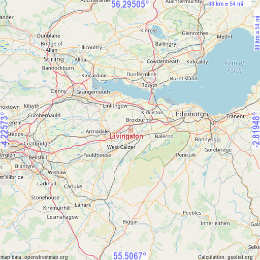
Livingston GPS coordinates[2]
55° 54' 10.368" North, 3° 31' 21.396" West
| Map corner | latitude | longitude |
|---|---|---|
| Upper-left | 56.29505°, | -4.22573° |
| Center: | 55.90288°, | -3.52261° |
| Lower-right: | 55.5067°, | -2.81948° |
| Map W x H: | 87.7×87.7 km | = 54.5×54.5mi |
| max Lat: | 60.39635° ⇑7.5% North |
| Livingston: | 55.90288° |
| min Lat: | ⇓92.5% South 34.60088° |
| min Long | Livingston | max Long |
| -7.64133° | -3.52261° | 32.95536° |
| W 17.4%⇐ | ⇒82.6% E |
Elevation
Elevation of Livingston is 157 m = 515 ft, and this is 84.1 m = 276 ft above average elevation for this country.
| Max E: |
515 m = 1690 ft | 8.6% |
| Livingston | 157 m 515 ft | |
| Avg. | 72.9 m = 239 ft | |
Min E: |
-30 m = -98 ft | 91.4% |
See also: Livingston elevation on elevation.city.
Geographical zone
Livingston is located in North temperate zone (between Tropic of Cancer and the Arctic Circle). Distance of this North polar circle is 1185.4 km =736.6 mi to North.| Distance of | km | miles | from Livingston |
|---|---|---|---|
| North Pole | 3791.2 | 2355.7 | to North |
| Arctic Circle | 1185.4 | 736.6 | to North |
| Tropic Cancer | 3609.9 | 2243.1 | to South |
| Equator | 6215.8 | 3862.3 | to South |


Nearby cities:
15 places around Livingston: (largest is in red/bold)
• Addiebrownhill
8.9 km =5.5 mi,  221°
221°
• Bathgate
7.6 km =4.7 mi,  269°
269°
• Blackburn
8 km =5 mi,  239°
239°
• Bridgend
6.8 km =4.2 mi,  353°
353°
• Broxburn
4.7 km =2.9 mi,  42°
42°
• Dechmont
2.2 km =1.4 mi,  337°
337°
• East Calder
3.9 km =2.4 mi,  108°
108°
• Kirknewton
6.7 km =4.2 mi,  104°
104°
• Mid Calder
2.9 km =1.8 mi, 113°
• Newbridge
8.4 km =5.2 mi,  66°
66°
• Polbeth
5 km =3.1 mi,  199°
199°
• Seafield
4.9 km =3 mi, 235°
• Torphichen
8.9 km =5.5 mi,  292°
292°
• West Calder
6.4 km =4 mi,  207°
207°
• Winchburgh
7.1 km =4.4 mi,  30°
30°
Sources, notices
• [Note1] Compared only with cities in United Kingdom existing in our database
• [Src1] Map data: © OpenStreetMap contributors (CC-BY-SA)
• [Src2] Other city data from geonames.org with taken over terms of usage.
• [Src3] Geographical zone / Annual Mean Temperature by Robert A. Rohde @ Wikipedia
