Lincoln geodata
Lincoln (England) is a seat of a second-order administrative division; located in United Kingdom in Europe/London (GMT+1) time zone. With population of 114,879 people, there are 82 cities with bigger population in this country. Compared to other cities in United Kingdom, 64.4% of cities are located further ↓South; 75.7% of cities are located further ←West and 93.6% of cities have higher elevation than Lincoln. Note1


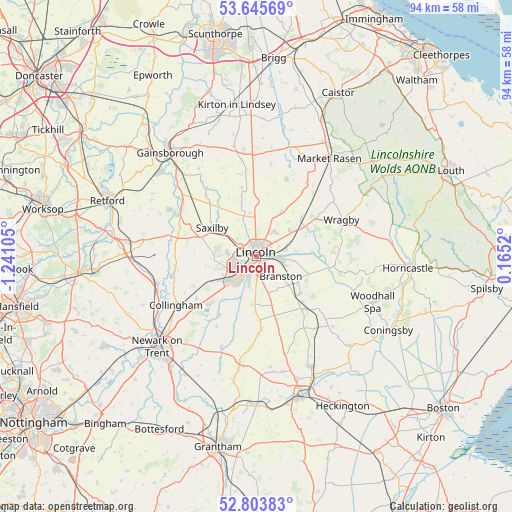
Lincoln GPS coordinates[2]
53° 13' 36.588" North, 0° 32' 16.512" West
| Map corner | latitude | longitude |
|---|---|---|
| Upper-left | 53.64569°, | -1.24105° |
| Center: | 53.22683°, | -0.53792° |
| Lower-right: | 52.80383°, | 0.1652° |
| Map W x H: | 93.6×93.6 km | = 58.2×58.2mi |
| max Lat: | 60.39635° ⇑35.6% North |
| Lincoln: | 53.22683° |
| min Lat: | ⇓64.4% South 34.60088° |
| min Long | Lincoln | max Long |
| -7.64133° | -0.53792° | 32.95536° |
| W 75.7%⇐ | ⇒24.3% E |
Elevation
Elevation of Lincoln is 9 m = 30 ft, and this is 63.9 m = 210 ft below average elevation for this country.
| Max E: |
515 m = 1690 ft | 93.6% |
| Avg. | 72.9 m = 239 ft | |
| Lincoln | 9 m = 30 ft | |
Min E: |
-30 m = -98 ft | 6.4% |
See also: Lincoln elevation on elevation.city.
Geographical zone
Lincoln is located in North temperate zone (between Tropic of Cancer and the Arctic Circle). Distance of this North polar circle is 1482.9 km =921.4 mi to North.| Distance of | km | miles | from Lincoln |
|---|---|---|---|
| North Pole | 4088.8 | 2540.7 | to North |
| Arctic Circle | 1482.9 | 921.4 | to North |
| Tropic Cancer | 3312.3 | 2058.2 | to South |
| Equator | 5918.3 | 3677.5 | to South |


Nearby cities:
15 places around Lincoln: (largest is in red/bold)
• Bracebridge Heath
3.4 km =2.1 mi,  175°
175°
• Branston
5.5 km =3.4 mi,  129°
129°
• Burton
4.8 km =3 mi,  336°
336°
• Dunholme
9.5 km =5.9 mi,  30°
30°
• Harmston
8.8 km =5.5 mi, 184°
• Heighington
5.5 km =3.4 mi,  106°
106°
• Nettleham
5.5 km =3.4 mi,  36°
36°
• Nocton
10.6 km =6.6 mi, 131°
• Reepham
7 km =4.3 mi,  84°
84°
• Saxilby
9.4 km =5.8 mi,  298°
298°
• Scothern
8.5 km =5.3 mi, 42°
• Skellingthorpe
5.5 km =3.4 mi,  279°
279°
• Sudbrooke
7.3 km =4.5 mi,  52°
52°
• Waddington
6.7 km =4.2 mi, 177°
• Washingborough
4.2 km =2.6 mi,  93°
93°
Sources, notices
• [Note1] Compared only with cities in United Kingdom existing in our database
• [Src1] Map data: © OpenStreetMap contributors (CC-BY-SA)
• [Src2] Other city data from geonames.org with taken over terms of usage.
• [Src3] Geographical zone / Annual Mean Temperature by Robert A. Rohde @ Wikipedia
