Leicester geodata
Leicester (England) is a seat of a second-order administrative division; located in United Kingdom in Europe/London (GMT+1) time zone. With population of 508,916 people, there are 7 cities with bigger population in this country. Compared to other cities in United Kingdom, 53.5% of cities are located further ↓South; 64.2% of cities are located further ←West and 53.1% of cities have lower elevation than Leicester. Note1


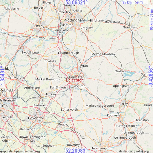
Leicester GPS coordinates[2]
52° 38' 18.96" North, 1° 7' 54.084" West
| Map corner | latitude | longitude |
|---|---|---|
| Upper-left | 53.06321°, | -1.83481° |
| Center: | 52.6386°, | -1.13169° |
| Lower-right: | 52.20983°, | -0.42856° |
| Map W x H: | 94.9×94.9 km | = 59×59mi |
| max Lat: | 60.39635° ⇑46.5% North |
| Leicester: | 52.6386° |
| min Lat: | ⇓53.5% South 34.60088° |
| min Long | Leicester | max Long |
| -7.64133° | -1.13169° | 32.95536° |
| W 64.2%⇐ | ⇒35.8% E |
Elevation
Elevation of Leicester is 65 m = 213 ft, and this is 7.9 m = 26 ft below average elevation for this country.
| Max E: |
515 m = 1690 ft | 46.9% |
| Avg. | 72.9 m = 239 ft | |
| Leicester | 65 m = 213 ft | |
Min E: |
-30 m = -98 ft | 53.1% |
See also: Leicester elevation on elevation.city.
Geographical zone
Leicester is located in North temperate zone (between Tropic of Cancer and the Arctic Circle). Distance of this North polar circle is 1548.3 km =962.1 mi to North.| Distance of | km | miles | from Leicester |
|---|---|---|---|
| North Pole | 4154.2 | 2581.3 | to North |
| Arctic Circle | 1548.3 | 962.1 | to North |
| Tropic Cancer | 3246.9 | 2017.5 | to South |
| Equator | 5852.9 | 3636.8 | to South |


Nearby cities:
15 places around Leicester: (largest is in red/bold)
• Anstey
5.5 km =3.4 mi,  315°
315°
• Blaby
7.3 km =4.5 mi,  197°
197°
• Enderby
7.6 km =4.7 mi,  221°
221°
• Glenfield
4.4 km =2.7 mi,  281°
281°
• Houghton on the Hill
9.3 km =5.8 mi,  98°
98°
• Kirby Muxloe
6.5 km =4 mi,  261°
261°
• Mountsorrel
8.8 km =5.5 mi,  351°
351°
• Narborough
9.2 km =5.7 mi,  209°
209°
• Newtown Limford
8.2 km =5.1 mi,  307°
307°
• Oadby
4.9 km =3 mi,  137°
137°
• Ratby
7.5 km =4.7 mi, 279°
• Rothley
7.9 km =4.9 mi,  357°
357°
• Syston
6.6 km =4.1 mi,  41°
41°
• Thurcaston
6.3 km =3.9 mi,  342°
342°
• Wigston Magna
6.9 km =4.3 mi,  157°
157°
Sources, notices
• [Note1] Compared only with cities in United Kingdom existing in our database
• [Src1] Map data: © OpenStreetMap contributors (CC-BY-SA)
• [Src2] Other city data from geonames.org with taken over terms of usage.
• [Src3] Geographical zone / Annual Mean Temperature by Robert A. Rohde @ Wikipedia
