Leatherhead geodata
Leatherhead (England) is a populated place; located in United Kingdom in Europe/London (GMT+1) time zone. With population of 43,544 people, there are 275 cities with bigger population in this country. Compared to other cities in United Kingdom, 84.4% of cities are located further ↑North; 80.2% of cities are located further ←West and 64% of cities have higher elevation than Leatherhead. Note1


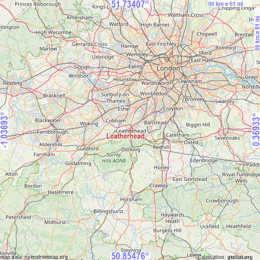
Leatherhead GPS coordinates[2]
51° 17' 47.472" North, 0° 20' 1.68" West
| Map corner | latitude | longitude |
|---|---|---|
| Upper-left | 51.73407°, | -1.03693° |
| Center: | 51.29652°, | -0.3338° |
| Lower-right: | 50.85476°, | 0.36933° |
| Map W x H: | 97.8×97.8 km | = 60.8×60.8mi |
| max Lat: | 60.39635° ⇑84.4% North |
| Leatherhead: | 51.29652° |
| min Lat: | ⇓15.6% South 34.60088° |
| min Long | Leatherhead | max Long |
| -7.64133° | -0.3338° | 32.95536° |
| W 80.2%⇐ | ⇒19.8% E |
Elevation
Elevation of Leatherhead is 41 m = 135 ft, and this is 31.9 m = 105 ft below average elevation for this country.
| Max E: |
515 m = 1690 ft | 64% |
| Avg. | 72.9 m = 239 ft | |
| Leatherhead | 41 m = 135 ft | |
Min E: |
-30 m = -98 ft | 36% |
See also: Leatherhead elevation on elevation.city.
Geographical zone
Leatherhead is located in North temperate zone (between Tropic of Cancer and the Arctic Circle). Distance of this North polar circle is 1697.5 km =1054.8 mi to North.| Distance of | km | miles | from Leatherhead |
|---|---|---|---|
| North Pole | 4303.4 | 2674 | to North |
| Arctic Circle | 1697.5 | 1054.8 | to North |
| Tropic Cancer | 3097.7 | 1924.8 | to South |
| Equator | 5703.6 | 3544.1 | to South |


Nearby cities:
15 places around Leatherhead: (largest is in red/bold)
• Ashtead
2.7 km =1.7 mi,  60°
60°
• Betchworth
8.4 km =5.2 mi,  146°
146°
• Chessington
7.6 km =4.7 mi,  15°
15°
• Cobham
6.5 km =4 mi,  304°
304°
• Dorking
7.1 km =4.4 mi,  180°
180°
• East Horsley
7.3 km =4.5 mi,  249°
249°
• Epsom
5.8 km =3.6 mi,  49°
49°
• Esher
8.5 km =5.3 mi,  344°
344°
• Ewell
8.3 km =5.2 mi,  44°
44°
• Great Bookham
3.4 km =2.1 mi,  235°
235°
• Headley
4.3 km =2.7 mi,  114°
114°
• Hook
8.2 km =5.1 mi,  13°
13°
• Mickleham
3.5 km =2.2 mi,  172°
172°
• Tadworth
6.8 km =4.2 mi,  94°
94°
• Westcott
8.4 km =5.2 mi,  198°
198°
Sources, notices
• [Note1] Compared only with cities in United Kingdom existing in our database
• [Src1] Map data: © OpenStreetMap contributors (CC-BY-SA)
• [Src2] Other city data from geonames.org with taken over terms of usage.
• [Src3] Geographical zone / Annual Mean Temperature by Robert A. Rohde @ Wikipedia
