Leafield geodata
Leafield (England) is a populated place; located in United Kingdom in Europe/London (GMT+1) time zone. With population of 945 people, there are 3734 cities with bigger population in this country. Compared to other cities in United Kingdom, 66.8% of cities are located further ↑North; 54.5% of cities are located further ←West and 94.7% of cities have lower elevation than Leafield. Note1
Administrative division(s):
- Level 1: England
- Level 2: Oxfordshire
- Level 3: West Oxfordshire District
- Level 4: Leafield


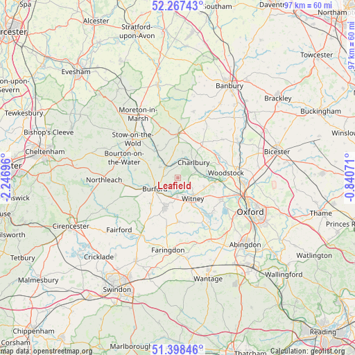
Leafield GPS coordinates[2]
51° 50' 6.144" North, 1° 32' 37.824" West
| Map corner | latitude | longitude |
|---|---|---|
| Upper-left | 52.26743°, | -2.24696° |
| Center: | 51.83504°, | -1.54384° |
| Lower-right: | 51.39846°, | -0.84071° |
| Map W x H: | 96.6×96.6 km | = 60×60mi |
| max Lat: | 60.39635° ⇑66.8% North |
| Leafield: | 51.83504° |
| min Lat: | ⇓33.2% South 34.60088° |
| min Long | Leafield | max Long |
| -7.64133° | -1.54384° | 32.95536° |
| W 54.5%⇐ | ⇒45.5% E |
Elevation
Elevation of Leafield is 182 m = 597 ft, and this is 109.1 m = 358 ft above average elevation for this country.
| Max E: |
515 m = 1690 ft | 5.3% |
| Leafield | 182 m 597 ft | |
| Avg. | 72.9 m = 239 ft | |
Min E: |
-30 m = -98 ft | 94.7% |
See also: United Kingdom elevation on elevation.city.
Geographical zone
Leafield is located in North temperate zone (between Tropic of Cancer and the Arctic Circle). Distance of this North polar circle is 1637.7 km =1017.6 mi to North.| Distance of | km | miles | from Leafield |
|---|---|---|---|
| North Pole | 4243.5 | 2636.8 | to North |
| Arctic Circle | 1637.7 | 1017.6 | to North |
| Tropic Cancer | 3157.6 | 1962 | to South |
| Equator | 5763.5 | 3581.3 | to South |


Nearby cities:
15 places around Leafield: (largest is in red/bold)
• Ascott under Wychwood
3.8 km =2.4 mi,  338°
338°
• Bledington
10.3 km =6.4 mi,  317°
317°
• Burford
7 km =4.3 mi,  245°
245°
• Carterton
9.1 km =5.7 mi,  202°
202°
• Chadlington
6.8 km =4.2 mi,  10°
10°
• Charlbury
5.9 km =3.7 mi,  45°
45°
• Chipping Norton
11.8 km =7.3 mi,  359°
359°
• Ducklington
8.5 km =5.3 mi,  151°
151°
• Enstone
10.9 km =6.8 mi,  34°
34°
• Kingham
10.4 km =6.5 mi,  328°
328°
• Minster Lovell
4.7 km =2.9 mi,  183°
183°
• North Leigh
7.4 km =4.6 mi,  108°
108°
• Shipton under Wychwood
4.7 km =2.9 mi,  306°
306°
• Stonesfield
8.1 km =5 mi,  76°
76°
• Witney
7 km =4.3 mi,  144°
144°
Sources, notices
• [Note1] Compared only with cities in United Kingdom existing in our database
• [Src1] Map data: © OpenStreetMap contributors (CC-BY-SA)
• [Src2] Other city data from geonames.org with taken over terms of usage.
• [Src3] Geographical zone / Annual Mean Temperature by Robert A. Rohde @ Wikipedia
