Laughton en le Morthen geodata
Laughton en le Morthen (England) is a populated place; located in United Kingdom in Europe/London (GMT+1) time zone. With population of 971 people, there are 3696 cities with bigger population in this country. Compared to other cities in United Kingdom, 67.6% of cities are located further ↓South; 62.2% of cities are located further ←West and 84.8% of cities have lower elevation than Laughton en le Morthen. Note1


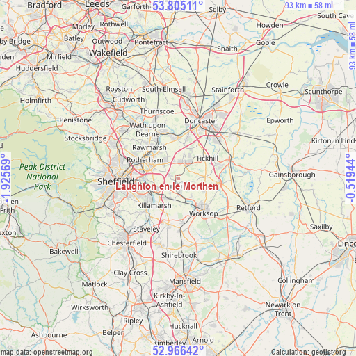
Laughton en le Morthen GPS coordinates[2]
53° 23' 16.188" North, 1° 13' 21.252" West
| Map corner | latitude | longitude |
|---|---|---|
| Upper-left | 53.80511°, | -1.92569° |
| Center: | 53.38783°, | -1.22257° |
| Lower-right: | 52.96642°, | -0.51944° |
| Map W x H: | 93.3×93.3 km | = 58×58mi |
| max Lat: | 60.39635° ⇑32.4% North |
| Laughton en le Morthen: | 53.38783° |
| min Lat: | ⇓67.6% South 34.60088° |
| min Long | Laughton en le | max Long |
| -7.64133° | -1.22257° | 32.95536° |
| W 62.2%⇐ | ⇒37.8% E |
Elevation
Elevation of Laughton en le Morthen is 132 m = 433 ft, and this is 59.1 m = 194 ft above average elevation for this country.
| Max E: |
515 m = 1690 ft | 15.2% |
| Laughton en le Morthen | 132 m 433 ft | |
| Avg. | 72.9 m = 239 ft | |
Min E: |
-30 m = -98 ft | 84.8% |
See also: United Kingdom elevation on elevation.city.
Geographical zone
Laughton en le Morthen is located in North temperate zone (between Tropic of Cancer and the Arctic Circle). Distance of this North polar circle is 1465 km =910.3 mi to North.| Distance of | km | miles | from Laughton en le Morthen |
|---|---|---|---|
| North Pole | 4070.9 | 2529.5 | to North |
| Arctic Circle | 1465 | 910.3 | to North |
| Tropic Cancer | 3330.3 | 2069.4 | to South |
| Equator | 5936.2 | 3688.6 | to South |


Nearby cities:
15 places around Laughton en le Morthen: (largest is in red/bold)
• Braithwell
6.7 km =4.2 mi,  12°
12°
• Bramley
4.3 km =2.7 mi,  317°
317°
• Dinnington
2.8 km =1.7 mi,  147°
147°
• Harthill
8.4 km =5.2 mi,  200°
200°
• Hellaby
4.1 km =2.5 mi,  342°
342°
• Kiveton Park
5.6 km =3.5 mi, 202°
• Maltby
3.5 km =2.2 mi,  25°
25°
• Stainton
6.3 km =3.9 mi,  36°
36°
• Tickhill
9 km =5.6 mi,  57°
57°
• Todwick
4.4 km =2.7 mi,  210°
210°
• Treeton
8.6 km =5.3 mi,  268°
268°
• Ulley
5.3 km =3.3 mi,  263°
263°
• Wales
6.6 km =4.1 mi,  216°
216°
• Whiston
6.6 km =4.1 mi,  290°
290°
• Woodsetts
5.6 km =3.5 mi,  142°
142°
Sources, notices
• [Note1] Compared only with cities in United Kingdom existing in our database
• [Src1] Map data: © OpenStreetMap contributors (CC-BY-SA)
• [Src2] Other city data from geonames.org with taken over terms of usage.
• [Src3] Geographical zone / Annual Mean Temperature by Robert A. Rohde @ Wikipedia
