Kirkcaldy geodata
Kirkcaldy (Scotland) is a populated place; located in United Kingdom in Europe/London (GMT+1) time zone. With population of 49,460 people, there are 237 cities with bigger population in this country. Compared to other cities in United Kingdom, 95.1% of cities are located further ↓South; 77.8% of cities are located further →East and 65.5% of cities have higher elevation than Kirkcaldy. Note1


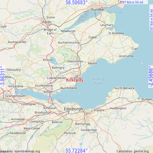
Kirkcaldy GPS coordinates[2]
56° 7' 0.588" North, 3° 9' 35.964" West
| Map corner | latitude | longitude |
|---|---|---|
| Upper-left | 56.50683°, | -3.86311° |
| Center: | 56.11683°, | -3.15999° |
| Lower-right: | 55.72284°, | -2.45686° |
| Map W x H: | 87.2×87.2 km | = 54.2×54.2mi |
| max Lat: | 60.39635° ⇑4.9% North |
| Kirkcaldy: | 56.11683° |
| min Lat: | ⇓95.1% South 34.60088° |
| min Long | Kirkcaldy | max Long |
| -7.64133° | -3.15999° | 32.95536° |
| W 22.2%⇐ | ⇒77.8% E |
Elevation
Elevation of Kirkcaldy is 39 m = 128 ft, and this is 33.9 m = 111 ft below average elevation for this country.
| Max E: |
515 m = 1690 ft | 65.5% |
| Avg. | 72.9 m = 239 ft | |
| Kirkcaldy | 39 m = 128 ft | |
Min E: |
-30 m = -98 ft | 34.5% |
See also: Kirkcaldy elevation on elevation.city.
Geographical zone
Kirkcaldy is located in North temperate zone (between Tropic of Cancer and the Arctic Circle). Distance of this North polar circle is 1161.6 km =721.8 mi to North.| Distance of | km | miles | from Kirkcaldy |
|---|---|---|---|
| North Pole | 3767.5 | 2341 | to North |
| Arctic Circle | 1161.6 | 721.8 | to North |
| Tropic Cancer | 3633.7 | 2257.9 | to South |
| Equator | 6239.6 | 3877.1 | to South |


Nearby cities:
15 places around Kirkcaldy: (largest is in red/bold)
• Aberdour
11.2 km =7 mi,  231°
231°
• Buckhaven
9.9 km =6.2 mi,  52°
52°
• Burntisland
7.5 km =4.7 mi,  216°
216°
• Cardenden
6.7 km =4.2 mi,  295°
295°
• Coaltown of Balgonie
7.8 km =4.8 mi,  15°
15°
• Coaltown of Wemyss
5.8 km =3.6 mi, 48°
• East Wemyss
7.6 km =4.7 mi, 50°
• Glenrothes
8.7 km =5.4 mi,  354°
354°
• Kinghorn
5.4 km =3.4 mi,  190°
190°
• Kinglassie
8.1 km =5 mi,  321°
321°
• Leslie
9.9 km =6.2 mi,  339°
339°
• Lochgelly
9.4 km =5.8 mi,  277°
277°
• Markinch
9.6 km =6 mi,  9°
9°
• Thornton
5.6 km =3.5 mi, 6°
• Windygates
11 km =6.8 mi,  37°
37°
Sources, notices
• [Note1] Compared only with cities in United Kingdom existing in our database
• [Src1] Map data: © OpenStreetMap contributors (CC-BY-SA)
• [Src2] Other city data from geonames.org with taken over terms of usage.
• [Src3] Geographical zone / Annual Mean Temperature by Robert A. Rohde @ Wikipedia
