Kilmarnock geodata
Kilmarnock (Scotland) is a seat of a second-order administrative division; located in United Kingdom in Europe/London (GMT+1) time zone. With population of 46,350 people, there are 254 cities with bigger population in this country. Compared to other cities in United Kingdom, 89.4% of cities are located further ↓South; 93.1% of cities are located further →East and 65.5% of cities have higher elevation than Kilmarnock. Note1


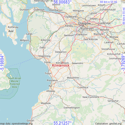
Kilmarnock GPS coordinates[2]
55° 36' 42.156" North, 4° 29' 44.916" West
| Map corner | latitude | longitude |
|---|---|---|
| Upper-left | 56.00683°, | -5.19894° |
| Center: | 55.61171°, | -4.49581° |
| Lower-right: | 55.21257°, | -3.79269° |
| Map W x H: | 88.3×88.3 km | = 54.9×54.9mi |
| max Lat: | 60.39635° ⇑10.6% North |
| Kilmarnock: | 55.61171° |
| min Lat: | ⇓89.4% South 34.60088° |
| min Long | Kilmarnock | max Long |
| -7.64133° | -4.49581° | 32.95536° |
| W 6.9%⇐ | ⇒93.1% E |
Elevation
Elevation of Kilmarnock is 39 m = 128 ft, and this is 33.9 m = 111 ft below average elevation for this country.
| Max E: |
515 m = 1690 ft | 65.5% |
| Avg. | 72.9 m = 239 ft | |
| Kilmarnock | 39 m = 128 ft | |
Min E: |
-30 m = -98 ft | 34.5% |
See also: Kilmarnock elevation on elevation.city.
Geographical zone
Kilmarnock is located in North temperate zone (between Tropic of Cancer and the Arctic Circle). Distance of this North polar circle is 1217.7 km =756.6 mi to North.| Distance of | km | miles | from Kilmarnock |
|---|---|---|---|
| North Pole | 3823.6 | 2375.9 | to North |
| Arctic Circle | 1217.7 | 756.6 | to North |
| Tropic Cancer | 3577.5 | 2223 | to South |
| Equator | 6183.4 | 3842.2 | to South |


Nearby cities:
15 places around Kilmarnock: (largest is in red/bold)
• Crosshouse
3.5 km =2.2 mi,  271°
271°
• Dreghorn
8 km =5 mi, 267°
• Dundonald
7.2 km =4.5 mi,  239°
239°
• Dunlop
11.4 km =7.1 mi,  347°
347°
• Fenwick
6.1 km =3.8 mi,  32°
32°
• Galston
7.3 km =4.5 mi,  99°
99°
• Irvine
10 km =6.2 mi, 274°
• Kilmaurs
3.5 km =2.2 mi,  325°
325°
• Loans
10.6 km =6.6 mi,  229°
229°
• Monkton
12.5 km =7.8 mi,  209°
209°
• Newmilns
10.8 km =6.7 mi,  92°
92°
• Springside
6 km =3.7 mi, 273°
• Stewarton
7.7 km =4.8 mi, 351°
• Symington
7.7 km =4.8 mi, 210°
• Tarbolton
11 km =6.8 mi,  176°
176°
Sources, notices
• [Note1] Compared only with cities in United Kingdom existing in our database
• [Src1] Map data: © OpenStreetMap contributors (CC-BY-SA)
• [Src2] Other city data from geonames.org with taken over terms of usage.
• [Src3] Geographical zone / Annual Mean Temperature by Robert A. Rohde @ Wikipedia
