Killearn geodata
Killearn (Scotland) is a populated place; located in United Kingdom in Europe/London (GMT+1) time zone. With population of 1,670 people, there are 2884 cities with bigger population in this country. Compared to other cities in United Kingdom, 94.5% of cities are located further ↓South; 92% of cities are located further →East and 69.8% of cities have lower elevation than Killearn. Note1


Killearn GPS coordinates[2]
56° 2' 32.604" North, 4° 22' 6.24" West
| Map corner | latitude | longitude |
|---|---|---|
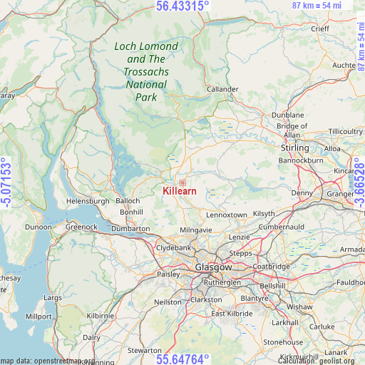
| Upper-left | 56.43315°, | -5.07153° |
| Center: | 56.04239°, | -4.3684° |
| Lower-right: | 55.64764°, | -3.66528° |
| Map W x H: | 87.3×87.3 km | = 54.2×54.2mi |
| max Lat: | 60.39635° ⇑5.5% North |
| Killearn: | 56.04239° |
| min Lat: | ⇓94.5% South 34.60088° |
| min Long | Killearn | max Long |
| -7.64133° | -4.3684° | 32.95536° |
| W 8%⇐ | ⇒92% E |
Elevation
Elevation of Killearn is 95 m = 312 ft, and this is 22.1 m = 73 ft above average elevation for this country.
| Max E: |
515 m = 1690 ft | 30.2% |
| Killearn | 95 m 312 ft | |
| Avg. | 72.9 m = 239 ft | |
Min E: |
-30 m = -98 ft | 69.8% |
See also: United Kingdom elevation on elevation.city.
Geographical zone
Killearn is located in North temperate zone (between Tropic of Cancer and the Arctic Circle). Distance of this North polar circle is 1169.8 km =726.9 mi to North.| Distance of | km | miles | from Killearn |
|---|---|---|---|
| North Pole | 3775.7 | 2346.1 | to North |
| Arctic Circle | 1169.8 | 726.9 | to North |
| Tropic Cancer | 3625.4 | 2252.7 | to South |
| Equator | 6231.3 | 3871.9 | to South |


Nearby cities:
15 places around Killearn: (largest is in red/bold)
• Alexandria
14.6 km =9.1 mi,  248°
248°
• Balfron
3.5 km =2.2 mi,  35°
35°
• Balloch
14.2 km =8.8 mi, 250°
• Bearsden
14.3 km =8.9 mi,  171°
171°
• Bonhill
14 km =8.7 mi,  240°
240°
• Bowling
14.4 km =8.9 mi,  210°
210°
• Buchlyvie
9.3 km =5.8 mi,  29°
29°
• Drymen
5.8 km =3.6 mi,  296°
296°
• Duntocher
13.4 km =8.3 mi,  192°
192°
• Faifley
12.7 km =7.9 mi,  184°
184°
• Lennoxtown
13 km =8.1 mi,  126°
126°
• Milngavie
11.7 km =7.3 mi, 166°
• Old Kilpatrick
14.4 km =8.9 mi,  202°
202°
• Strathblane
7.4 km =4.6 mi,  148°
148°
• Torrance
15 km =9.3 mi,  139°
139°
Sources, notices
• [Note1] Compared only with cities in United Kingdom existing in our database
• [Src1] Map data: © OpenStreetMap contributors (CC-BY-SA)
• [Src2] Other city data from geonames.org with taken over terms of usage.
• [Src3] Geographical zone / Annual Mean Temperature by Robert A. Rohde @ Wikipedia
