Keighley geodata
Keighley (England) is a seat of a third-order administrative division; located in United Kingdom in Europe/London (GMT+1) time zone. With population of 50,171 people, there are 233 cities with bigger population in this country. Compared to other cities in United Kingdom, 76.7% of cities are located further ↓South; 53.1% of cities are located further →East and 75.7% of cities have lower elevation than Keighley. Note1


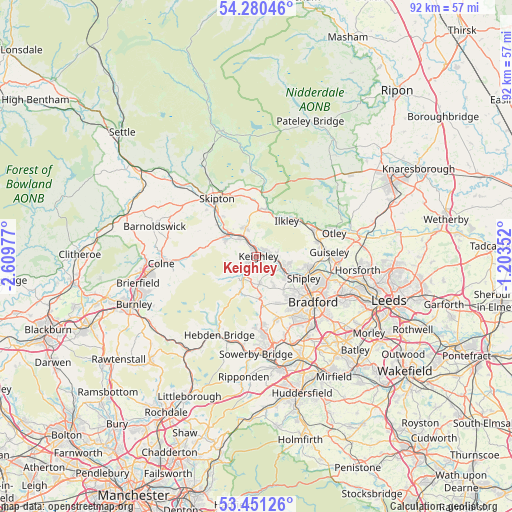
Keighley GPS coordinates[2]
53° 52' 4.476" North, 1° 54' 23.904" West
| Map corner | latitude | longitude |
|---|---|---|
| Upper-left | 54.28046°, | -2.60977° |
| Center: | 53.86791°, | -1.90664° |
| Lower-right: | 53.45126°, | -1.20352° |
| Map W x H: | 92.2×92.2 km | = 57.3×57.3mi |
| max Lat: | 60.39635° ⇑23.3% North |
| Keighley: | 53.86791° |
| min Lat: | ⇓76.7% South 34.60088° |
| min Long | Keighley | max Long |
| -7.64133° | -1.90664° | 32.95536° |
| W 46.9%⇐ | ⇒53.1% E |
Elevation
Elevation of Keighley is 108 m = 354 ft, and this is 35.1 m = 115 ft above average elevation for this country.
| Max E: |
515 m = 1690 ft | 24.3% |
| Keighley | 108 m 354 ft | |
| Avg. | 72.9 m = 239 ft | |
Min E: |
-30 m = -98 ft | 75.7% |
See also: Keighley elevation on elevation.city.
Geographical zone
Keighley is located in North temperate zone (between Tropic of Cancer and the Arctic Circle). Distance of this North polar circle is 1411.6 km =877.1 mi to North.| Distance of | km | miles | from Keighley |
|---|---|---|---|
| North Pole | 4017.5 | 2496.4 | to North |
| Arctic Circle | 1411.6 | 877.1 | to North |
| Tropic Cancer | 3383.6 | 2102.5 | to South |
| Equator | 5989.6 | 3721.8 | to South |


Nearby cities:
15 places around Keighley: (largest is in red/bold)
• Addingham
8.6 km =5.3 mi,  9°
9°
• Baildon
8.1 km =5 mi,  106°
106°
• Bingley
5 km =3.1 mi,  115°
115°
• Cononley
9.1 km =5.7 mi,  307°
307°
• Cross Hills
6.7 km =4.2 mi, 309°
• Cullingworth
4.9 km =3 mi,  172°
172°
• Denholme
7.4 km =4.6 mi, 174°
• Glusburn
7.1 km =4.4 mi,  300°
300°
• Haworth
5.1 km =3.2 mi,  212°
212°
• Ilkley
8.3 km =5.2 mi,  40°
40°
• Low Bradley
9.3 km =5.8 mi,  320°
320°
• Oxenhope
6.9 km =4.3 mi, 205°
• Silsden
5.6 km =3.5 mi,  338°
338°
• Steeton
3.3 km =2.1 mi, 301°
• Wilsden
6.1 km =3.8 mi,  149°
149°
Sources, notices
• [Note1] Compared only with cities in United Kingdom existing in our database
• [Src1] Map data: © OpenStreetMap contributors (CC-BY-SA)
• [Src2] Other city data from geonames.org with taken over terms of usage.
• [Src3] Geographical zone / Annual Mean Temperature by Robert A. Rohde @ Wikipedia
