Ipswich geodata
Ipswich (England) is a seat of a second-order administrative division; located in United Kingdom in Europe/London (GMT+1) time zone. With population of 178,835 people, there are 45 cities with bigger population in this country. Compared to other cities in United Kingdom, 60.4% of cities are located further ↑North; 97.4% of cities are located further ←West and 82.8% of cities have higher elevation than Ipswich. Note1


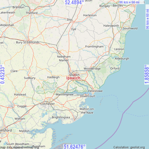
Ipswich GPS coordinates[2]
52° 3' 33.012" North, 1° 9' 19.62" East
| Map corner | latitude | longitude |
|---|---|---|
| Upper-left | 52.4894°, | 0.45233° |
| Center: | 52.05917°, | 1.15545° |
| Lower-right: | 51.62476°, | 1.85858° |
| Map W x H: | 96.1×96.1 km | = 59.7×59.7mi |
| max Lat: | 60.39635° ⇑60.4% North |
| Ipswich: | 52.05917° |
| min Lat: | ⇓39.6% South 34.60088° |
| min Long | Ipswich | max Long |
| -7.64133° | 1.15545° | 32.95536° |
| W 97.4%⇐ | ⇒2.6% E |
Elevation
Elevation of Ipswich is 18 m = 59 ft, and this is 54.9 m = 180 ft below average elevation for this country.
| Max E: |
515 m = 1690 ft | 82.8% |
| Avg. | 72.9 m = 239 ft | |
| Ipswich | 18 m = 59 ft | |
Min E: |
-30 m = -98 ft | 17.2% |
See also: Ipswich elevation on elevation.city.
Geographical zone
Ipswich is located in North temperate zone (between Tropic of Cancer and the Arctic Circle). Distance of this North polar circle is 1612.7 km =1002.1 mi to North.| Distance of | km | miles | from Ipswich |
|---|---|---|---|
| North Pole | 4218.6 | 2621.3 | to North |
| Arctic Circle | 1612.7 | 1002.1 | to North |
| Tropic Cancer | 3182.5 | 1977.5 | to South |
| Equator | 5788.4 | 3596.7 | to South |


Nearby cities:
15 places around Ipswich: (largest is in red/bold)
• Bramford
4.4 km =2.7 mi,  295°
295°
• Bucklesham
8.4 km =5.2 mi,  112°
112°
• Capel Saint Mary
9.8 km =6.1 mi,  230°
230°
• Chelmondiston
8.7 km =5.4 mi,  153°
153°
• Claydon
6.1 km =3.8 mi,  330°
330°
• Coddenham
10 km =6.2 mi,  344°
344°
• Grundisburgh
8.6 km =5.3 mi,  46°
46°
• Henley
6.6 km =4.1 mi,  356°
356°
• Holbrook
8.4 km =5.2 mi,  178°
178°
• Kesgrave
5.6 km =3.5 mi,  86°
86°
• Otley
11.2 km =7 mi,  23°
23°
• Shotley
11.9 km =7.4 mi, 146°
• Sproughton
4.1 km =2.5 mi,  274°
274°
• Stutton
10 km =6.2 mi,  189°
189°
• Woodbridge
11.9 km =7.4 mi,  71°
71°
Sources, notices
• [Note1] Compared only with cities in United Kingdom existing in our database
• [Src1] Map data: © OpenStreetMap contributors (CC-BY-SA)
• [Src2] Other city data from geonames.org with taken over terms of usage.
• [Src3] Geographical zone / Annual Mean Temperature by Robert A. Rohde @ Wikipedia
