Inverbervie geodata
Inverbervie (Scotland) is a populated place; located in United Kingdom in Europe/London (GMT+1) time zone. With population of 2,310 people, there are 2442 cities with bigger population in this country. Compared to other cities in United Kingdom, 97.3% of cities are located further ↓South; 60.8% of cities are located further →East and 72.3% of cities have higher elevation than Inverbervie. Note1


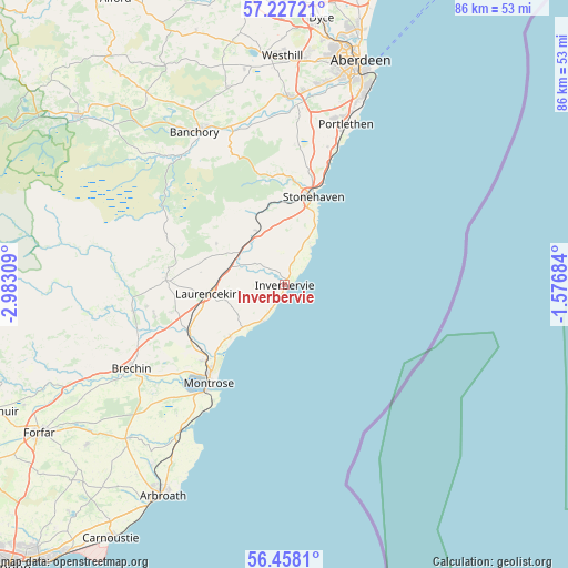
Inverbervie GPS coordinates[2]
56° 50' 40.668" North, 2° 16' 47.892" West
| Map corner | latitude | longitude |
|---|---|---|
| Upper-left | 57.22721°, | -2.98309° |
| Center: | 56.84463°, | -2.27997° |
| Lower-right: | 56.4581°, | -1.57684° |
| Map W x H: | 85.5×85.5 km | = 53.1×53.1mi |
| max Lat: | 60.39635° ⇑2.7% North |
| Inverbervie: | 56.84463° |
| min Lat: | ⇓97.3% South 34.60088° |
| min Long | Inverbervie | max Long |
| -7.64133° | -2.27997° | 32.95536° |
| W 39.2%⇐ | ⇒60.8% E |
Elevation
Elevation of Inverbervie is 30 m = 98 ft, and this is 42.9 m = 141 ft below average elevation for this country.
| Max E: |
515 m = 1690 ft | 72.3% |
| Avg. | 72.9 m = 239 ft | |
| Inverbervie | 30 m = 98 ft | |
Min E: |
-30 m = -98 ft | 27.7% |
See also: United Kingdom elevation on elevation.city.
Geographical zone
Inverbervie is located in North temperate zone (between Tropic of Cancer and the Arctic Circle). Distance of this North polar circle is 1080.6 km =671.5 mi to North.| Distance of | km | miles | from Inverbervie |
|---|---|---|---|
| North Pole | 3686.5 | 2290.7 | to North |
| Arctic Circle | 1080.6 | 671.5 | to North |
| Tropic Cancer | 3714.6 | 2308.1 | to South |
| Equator | 6320.5 | 3927.4 | to South |


Nearby cities:
15 places around Inverbervie: (largest is in red/bold)
• Auchenblae
12 km =7.5 mi,  300°
300°
• Banchory
26.3 km =16.3 mi,  331°
331°
• Brechin
26.3 km =16.3 mi,  240°
240°
• Drumoak
26.4 km =16.4 mi,  351°
351°
• Edzell
23.2 km =14.4 mi,  260°
260°
• Ferryden
19.5 km =12.1 mi,  215°
215°
• Gourdon
1.7 km =1.1 mi,  193°
193°
• Hillside
16.2 km =10.1 mi,  226°
226°
• Johnshaven
6.6 km =4.1 mi,  211°
211°
• Laurencekirk
11.3 km =7 mi, 263°
• Montrose
18.2 km =11.3 mi, 218°
• Newtonhill
22.4 km =13.9 mi,  20°
20°
• Portlethen
26.5 km =16.5 mi, 19°
• Saint Cyrus
11.3 km =7 mi, 226°
• Stonehaven
13.9 km =8.6 mi, 17°
Sources, notices
• [Note1] Compared only with cities in United Kingdom existing in our database
• [Src1] Map data: © OpenStreetMap contributors (CC-BY-SA)
• [Src2] Other city data from geonames.org with taken over terms of usage.
• [Src3] Geographical zone / Annual Mean Temperature by Robert A. Rohde @ Wikipedia
