Holyhead geodata
Holyhead (Wales) is a seat of a third-order administrative division; located in United Kingdom in Europe/London (GMT+1) time zone. With population of 11,431 people, there are 950 cities with bigger population in this country. Compared to other cities in United Kingdom, 66.2% of cities are located further ↓South; 94.3% of cities are located further →East and 94.9% of cities have higher elevation than Holyhead. Note1


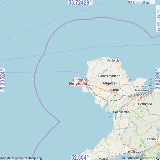
Holyhead GPS coordinates[2]
53° 18' 22.356" North, 4° 37' 55.596" West
| Map corner | latitude | longitude |
|---|---|---|
| Upper-left | 53.72429°, | -5.33524° |
| Center: | 53.30621°, | -4.63211° |
| Lower-right: | 52.884°, | -3.92899° |
| Map W x H: | 93.4×93.4 km | = 58×58mi |
| max Lat: | 60.39635° ⇑33.8% North |
| Holyhead: | 53.30621° |
| min Lat: | ⇓66.2% South 34.60088° |
| min Long | Holyhead | max Long |
| -7.64133° | -4.63211° | 32.95536° |
| W 5.7%⇐ | ⇒94.3% E |
Elevation
Elevation of Holyhead is 8 m = 26 ft, and this is 64.9 m = 213 ft below average elevation for this country.
| Max E: |
515 m = 1690 ft | 94.9% |
| Avg. | 72.9 m = 239 ft | |
| Holyhead | 8 m = 26 ft | |
Min E: |
-30 m = -98 ft | 5.1% |
See also: United Kingdom elevation on elevation.city.
Geographical zone
Holyhead is located in North temperate zone (between Tropic of Cancer and the Arctic Circle). Distance of this North polar circle is 1474.1 km =916 mi to North.| Distance of | km | miles | from Holyhead |
|---|---|---|---|
| North Pole | 4080 | 2535.2 | to North |
| Arctic Circle | 1474.1 | 916 | to North |
| Tropic Cancer | 3321.2 | 2063.7 | to South |
| Equator | 5927.1 | 3682.9 | to South |


Nearby cities:
15 places around Holyhead: (largest is in red/bold)
• Aberffraw
16.8 km =10.4 mi,  138°
138°
• Amlwch
22.1 km =13.7 mi,  58°
58°
• Bodedern
8.7 km =5.4 mi,  100°
100°
• Cemaes Bay
16.8 km =10.4 mi,  45°
45°
• Dwyran
25.8 km =16 mi,  126°
126°
• Gaerwen
25.7 km =16 mi,  111°
111°
• Gwalchmai
15.2 km =9.4 mi, 110°
• Llanerchymedd
17.2 km =10.7 mi,  80°
80°
• Llanfachraeth
6.6 km =4.1 mi, 83°
• Llanfaethlu
8.3 km =5.2 mi, 51°
• Llanfechell
15.1 km =9.4 mi, 50°
• Llangefni
22.1 km =13.7 mi, 104°
• Penysarn
22.9 km =14.2 mi,  66°
66°
• Rhosneigr
11.4 km =7.1 mi, 136°
• Valley
5 km =3.1 mi,  118°
118°
Sources, notices
• [Note1] Compared only with cities in United Kingdom existing in our database
• [Src1] Map data: © OpenStreetMap contributors (CC-BY-SA)
• [Src2] Other city data from geonames.org with taken over terms of usage.
• [Src3] Geographical zone / Annual Mean Temperature by Robert A. Rohde @ Wikipedia
