Hitcham geodata
Hitcham (England) is a populated place; located in United Kingdom in Europe/London (GMT+1) time zone. With population of 774 people, there are 4086 cities with bigger population in this country. Compared to other cities in United Kingdom, 58.4% of cities are located further ↑North; 95.7% of cities are located further ←West and 53% of cities have higher elevation than Hitcham. Note1
Administrative division(s):
- Level 1: England
- Level 2: Suffolk
- Level 3: Babergh District
- Level 4: Hitcham


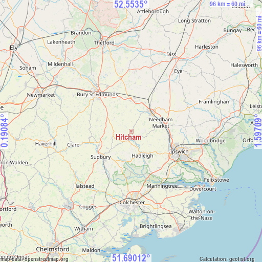
Hitcham GPS coordinates[2]
52° 7' 26.04" North, 0° 53' 38.292" East
| Map corner | latitude | longitude |
|---|---|---|
| Upper-left | 52.5535°, | 0.19084° |
| Center: | 52.1239°, | 0.89397° |
| Lower-right: | 51.69012°, | 1.59709° |
| Map W x H: | 96×96 km | = 59.7×59.7mi |
| max Lat: | 60.39635° ⇑58.4% North |
| Hitcham: | 52.1239° |
| min Lat: | ⇓41.6% South 34.60088° |
| min Long | Hitcham | max Long |
| -7.64133° | 0.89397° | 32.95536° |
| W 95.7%⇐ | ⇒4.3% E |
Elevation
Elevation of Hitcham is 56 m = 184 ft, and this is 16.9 m = 55 ft below average elevation for this country.
| Max E: |
515 m = 1690 ft | 53% |
| Avg. | 72.9 m = 239 ft | |
| Hitcham | 56 m = 184 ft | |
Min E: |
-30 m = -98 ft | 47% |
See also: United Kingdom elevation on elevation.city.
Geographical zone
Hitcham is located in North temperate zone (between Tropic of Cancer and the Arctic Circle). Distance of this North polar circle is 1605.5 km =997.6 mi to North.| Distance of | km | miles | from Hitcham |
|---|---|---|---|
| North Pole | 4211.4 | 2616.8 | to North |
| Arctic Circle | 1605.5 | 997.6 | to North |
| Tropic Cancer | 3189.7 | 1982 | to South |
| Equator | 5795.6 | 3601.2 | to South |


Nearby cities:
15 places around Hitcham: (largest is in red/bold)
• Beyton
13 km =8.1 mi,  340°
340°
• Bildeston
2.2 km =1.4 mi,  151°
151°
• Boxford
10.9 km =6.8 mi,  192°
192°
• Elmswell
12.5 km =7.8 mi,  5°
5°
• Great Finborough
7.1 km =4.4 mi,  27°
27°
• Great Waldingfield
11.2 km =7 mi,  227°
227°
• Hadleigh
9.7 km =6 mi,  155°
155°
• Haughley
11.7 km =7.3 mi, 25°
• Lavenham
6.9 km =4.3 mi,  255°
255°
• Lawshall
11.8 km =7.3 mi,  287°
287°
• Monks Eleigh
4 km =2.5 mi,  206°
206°
• Needham Market
11.3 km =7 mi,  71°
71°
• Stowmarket
10.1 km =6.3 mi,  44°
44°
• Wattisham
3.1 km =1.9 mi,  86°
86°
• Woolpit
11.2 km =7 mi,  358°
358°
Sources, notices
• [Note1] Compared only with cities in United Kingdom existing in our database
• [Src1] Map data: © OpenStreetMap contributors (CC-BY-SA)
• [Src2] Other city data from geonames.org with taken over terms of usage.
• [Src3] Geographical zone / Annual Mean Temperature by Robert A. Rohde @ Wikipedia
