Hereford geodata
Hereford (England) is a seat of a second-order administrative division; located in United Kingdom in Europe/London (GMT+1) time zone. With population of 60,415 people, there are 181 cities with bigger population in this country. Compared to other cities in United Kingdom, 60.5% of cities are located further ↑North; 69% of cities are located further →East and 50.3% of cities have lower elevation than Hereford. Note1


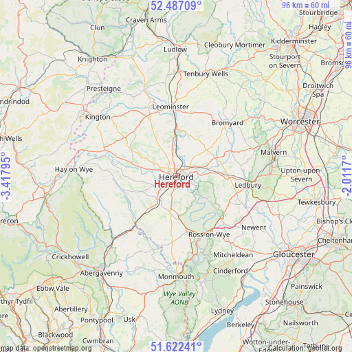
Hereford GPS coordinates[2]
52° 3' 24.624" North, 2° 42' 53.352" West
| Map corner | latitude | longitude |
|---|---|---|
| Upper-left | 52.48709°, | -3.41795° |
| Center: | 52.05684°, | -2.71482° |
| Lower-right: | 51.62241°, | -2.0117° |
| Map W x H: | 96.1×96.1 km | = 59.7×59.7mi |
| max Lat: | 60.39635° ⇑60.5% North |
| Hereford: | 52.05684° |
| min Lat: | ⇓39.5% South 34.60088° |
| min Long | Hereford | max Long |
| -7.64133° | -2.71482° | 32.95536° |
| W 31%⇐ | ⇒69% E |
Elevation
Elevation of Hereford is 61 m = 200 ft, and this is 11.9 m = 39 ft below average elevation for this country.
| Max E: |
515 m = 1690 ft | 49.7% |
| Avg. | 72.9 m = 239 ft | |
| Hereford | 61 m = 200 ft | |
Min E: |
-30 m = -98 ft | 50.3% |
See also: Hereford elevation on elevation.city.
Geographical zone
Hereford is located in North temperate zone (between Tropic of Cancer and the Arctic Circle). Distance of this North polar circle is 1613 km =1002.3 mi to North.| Distance of | km | miles | from Hereford |
|---|---|---|---|
| North Pole | 4218.9 | 2621.5 | to North |
| Arctic Circle | 1613 | 1002.3 | to North |
| Tropic Cancer | 3182.3 | 1977.4 | to South |
| Equator | 5788.2 | 3596.6 | to South |


Nearby cities:
15 places around Hereford: (largest is in red/bold)
• Belmont
2.4 km =1.5 mi,  229°
229°
• Bridge Sollers
10.2 km =6.3 mi,  282°
282°
• Callow
4.6 km =2.9 mi,  195°
195°
• Credenhill
7 km =4.3 mi,  294°
294°
• Fownhope
8.7 km =5.4 mi,  128°
128°
• Kingstone
9.3 km =5.8 mi,  241°
241°
• Lower Bullingham
2.8 km =1.7 mi,  158°
158°
• Lugwardine
4 km =2.5 mi,  75°
75°
• Madley
9.4 km =5.8 mi,  262°
262°
• Moreton on Lugg
5.6 km =3.5 mi,  354°
354°
• Much Birch
9.6 km =6 mi,  183°
183°
• Sutton
5.3 km =3.3 mi,  24°
24°
• Thruxton
9.4 km =5.8 mi, 227°
• Wellington
8.3 km =5.2 mi, 346°
• Withington
7.4 km =4.6 mi,  49°
49°
Sources, notices
• [Note1] Compared only with cities in United Kingdom existing in our database
• [Src1] Map data: © OpenStreetMap contributors (CC-BY-SA)
• [Src2] Other city data from geonames.org with taken over terms of usage.
• [Src3] Geographical zone / Annual Mean Temperature by Robert A. Rohde @ Wikipedia
