Henllan geodata
Henllan (Wales) is a seat of a third-order administrative division; located in United Kingdom in Europe/London (GMT+1) time zone. With population of 862 people, there are 3895 cities with bigger population in this country. Compared to other cities in United Kingdom, 63.9% of cities are located further ↓South; 81.7% of cities are located further →East and 75.2% of cities have lower elevation than Henllan. Note1


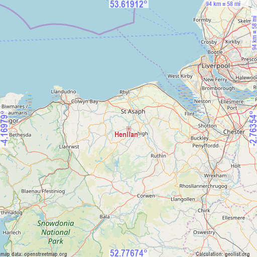
Henllan GPS coordinates[2]
53° 12' 0" North, 3° 28' 0.012" West
| Map corner | latitude | longitude |
|---|---|---|
| Upper-left | 53.61912°, | -4.16979° |
| Center: | 53.2°, | -3.46667° |
| Lower-right: | 52.77674°, | -2.76354° |
| Map W x H: | 93.7×93.7 km | = 58.2×58.2mi |
| max Lat: | 60.39635° ⇑36.1% North |
| Henllan: | 53.2° |
| min Lat: | ⇓63.9% South 34.60088° |
| min Long | Henllan | max Long |
| -7.64133° | -3.46667° | 32.95536° |
| W 18.3%⇐ | ⇒81.7% E |
Elevation
Elevation of Henllan is 107 m = 351 ft, and this is 34.1 m = 112 ft above average elevation for this country.
| Max E: |
515 m = 1690 ft | 24.8% |
| Henllan | 107 m 351 ft | |
| Avg. | 72.9 m = 239 ft | |
Min E: |
-30 m = -98 ft | 75.2% |
See also: United Kingdom elevation on elevation.city.
Geographical zone
Henllan is located in North temperate zone (between Tropic of Cancer and the Arctic Circle). Distance of this North polar circle is 1485.9 km =923.3 mi to North.| Distance of | km | miles | from Henllan |
|---|---|---|---|
| North Pole | 4091.8 | 2542.5 | to North |
| Arctic Circle | 1485.9 | 923.3 | to North |
| Tropic Cancer | 3309.4 | 2056.4 | to South |
| Equator | 5915.3 | 3675.6 | to South |


Nearby cities:
15 places around Henllan: (largest is in red/bold)
• Abergele
12.1 km =7.5 mi,  320°
320°
• Bodelwyddan
7.9 km =4.9 mi,  343°
343°
• Caerwys
11.8 km =7.3 mi,  63°
63°
• Cwm
10.3 km =6.4 mi,  25°
25°
• Denbigh
3.8 km =2.4 mi,  119°
119°
• Dyserth
11.7 km =7.3 mi,  17°
17°
• Llandyrnog
9.1 km =5.7 mi,  107°
107°
• Llysfaen
16.2 km =10.1 mi,  304°
304°
• Prestatyn
15.8 km =9.8 mi,  14°
14°
• Rhuddlan
10.2 km =6.3 mi,  358°
358°
• Rhyl
13.4 km =8.3 mi,  352°
352°
• Ruthin
13.8 km =8.6 mi,  134°
134°
• Saint Asaph
6.6 km =4.1 mi, 12°
• Trefnant
4.2 km =2.6 mi,  47°
47°
• Whitford
15.3 km =9.5 mi, 52°
Sources, notices
• [Note1] Compared only with cities in United Kingdom existing in our database
• [Src1] Map data: © OpenStreetMap contributors (CC-BY-SA)
• [Src2] Other city data from geonames.org with taken over terms of usage.
• [Src3] Geographical zone / Annual Mean Temperature by Robert A. Rohde @ Wikipedia
